Average end to the year but fun one day

Victorian Surf Forecast by Craig Brokensha (issued Monday 27th December)
Best Days: Thursday until the sea breezes kick in, desperate surfers early Friday exposed beaches
Features of the Forecast (tl;dr)
- Easing S/SW swell over the coming days with mod-fresh E/SE tending strong S/SE winds tomorrow, moderate S/SE but fresheing Wed
- Inconsistent mid-period SW swell Thu with light N/NE winds ahead of mid-late afternoon sea breezes
- Fading surf Fri with variable tending S/SW winds
- Small weekend with variable winds Sat AM, S'ly Sun
- Small-mod sized W/SW swell for Mon with S/SE winds, easing Tue with E/NE tending SE winds
Recap
Poor surf all weekend with a low point in swell Christmas morning, while yesterday we saw some strong, new S/SW groundswell filling in. It got sizey into the afternoon but conditions were average and options little to none.
This morning the swell was still a good size, easing from 3-4ft on the Surf Coast and 6ft to the east on the sets.
This week and weekend (Dec 27 – Jan 2)
The current, moderate sized S/SW groundswell breaking across the state will ease over the coming days and winds will unfortunately be onshore and not really improve until Thursday.
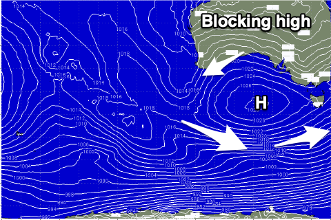
 A slow moving high pushing in from the west will take its time doing so, with the trough on the East Coast being pushed further north than forecast last week. This won't squeeze the high as well, so winds will take their time to go east and then north-east.
A moderate to fresh E/SE breeze is due tomorrow morning with easing surf from 2ft+ on the Surf Coast and 3ft to maybe 4ft to the east. Winds will shift S/SE and strengthen through the day creating deteriorating conditions.
Wednesday will see a low point in swell with a lingering, moderate S/SE breeze.
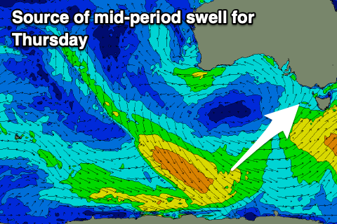
Our small, mid-period SW swell for later Wednesday and Thursday morning is still in the mix, though as pointed out on Friday, the source of this swell is now much weaker than that linked to the current swell.
Size wise it'll be inconsistent but coming in around 2ft+ on the Surf Coast and 3-4ft to the east with a light N/NE offshore ahead of mid-late afternoon S/SE sea breezes. It might be a little lumpy and peaky on the beaches but this is the pick of the week.
 Come Friday we'll see variable winds through the morning ahead of a shallow. S/SW change as a weak trough moves through. Size wise it'll be small and easing from 1-2ft and 2-3ft respectively.
There's no decent swell due into the weekend with the slow moving high blocking our swell window through this week. Winds will be variable Saturday morning ahead of a weak S'ly breeze but with no decent size, while Sunday looks average with a freshening S/SE breeze.
Late this week, a weak frontal progression pushing up towards Western Australia and under the Bight should generate a new mid-period W/SW swell for late Sunday but more so Monday.
Size wise the Surf Coast looks to come in around 3ft Monday with 4-5ft+ waves to the east but a slow moving high pushing in through early next week will bring S/SE winds, possibly tending E/NE on Tuesday as the swell eases. We'll have a closer look at this Wednesday.
Comments
Just as you’d expect for the holidays.. disastrous!
its dogshit isn't it? Mehh
Hundescheiße