Upgrade in swell for Sunday/Monday but onshore

Victorian Surf Forecast by Craig Brokensha (issued Friday 24th December)
Best Days: Today ahead of the sea breeze, Wednesday morning exposed beaches, Thursday, Friday morning exposed beaches
Features of the Forecast (tl;dr)
- Small, fading mid-period S/SW swell tomorrow with early light winds, strengthening from the S/SW from late morning
- Moderate sized S/SW groundswell building Sun with fresh S/SW winds, strengthening into the PM
- Easing S/SW swell Mon with strong S'ly winds at dawn, abating quickly during the morning east of Melbourne, then fresh S/SE
- Further drop in S/SW swell Tue with gusty E/SE tending S/SE winds
- Small Wed with fresh E/NE tending SE winds
- Late pulse of mid-period SW swell Wed, peaking Thu with fresh N/NE winds
- Easing surf Fri with strong N/NE tending S/SW winds
Recap
Wednesday's large pulse of swells held well into yesterday morning with straight, strong 4-5ft sets continuing across the Surf Coast with 6ft+ sets to the east. Winds were light and variable creating decent conditions west of Melbourne, with workable waves to the east as well. Sea breezes added bumps as the swell eased into the afternoon.
This morning the swell has dropped more noticeably with easing sets from 3ft on the Surf Coast and 3-5ft to the east. Get in this morning before sea breezes kick in.

Still sets and good conditions on the beaches
This weekend and next week (Dec 25 - 31)
We'll see the swell continuing to ease into tomorrow, becoming weaker in period and size resulting in fading 1-2ft sets on the Surf Coast with 2-3ft sets to the east. Winds are now looking favourable early with a light W/NW breeze west of Melbourne with light SW winds to the east. Winds are due to freshen from the S/SW from late morning, stronger later in the day. So while not great there should be small, workable waves for keen surfers early across most regions.
Moving into Sunday it'll be poor with fresh S/SW winds, strengthening through the afternoon again kicking up some weak, local windswell.
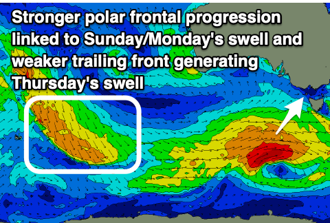 Into the afternoon a better pulse of S/SW groundswell is due to fill in, with it arriving earlier than forecast on Wednesday. This is due to the polar frontal progression linked to it being a little stronger with W/SW gales now due to generated south-west of Tasmania from this afternoon through tomorrow.
Size wise we should see good 4ft sets building on the Surf Coast if not for the odd bigger one late in the day but with that strong S/SW-S breeze with 6ft sets to the east.
Monday should offer similar sized 3-4ft waves on the Surf Coast and 6ft sets to the east, easing through the day as winds remain strong from the S'th at dawn, though easing rapidly east of Melbourne through the morning as a small trough pushes in from the east. This will see improving conditions but likely not enough to create good enough surf for a paddle.
Unfortunately winds will remain gusty from the E/SE on Tuesday as the swell from Sunday and Monday continues to ease. The Surf Coast looks to be easing from 2ft+ with 3ft to maybe 4ft sets to the east.
From Wednesday we'll see winds improving for the beaches, shifting E/NE in the morning but we'll be in between swells. Our, new SW swell for the late afternoon and Thursday morning is on track but this now looks weaker and mid-period energy.
The source of this swell was going to be a polar low forming behind the frontal progression firing up south-west of Tasmania, but it looks like all the energy has gone into the frontal progression and not the low now. Instead we'll see a broad fetch of unfavourably aligned strong to gale-force NW tending W/NW winds swinging in from the Indian Ocean. This will produce a smaller, mid-period swell that should build later Wednesday afternoon and peak Thursday morning to 2ft+ on the Surf Coast and 3-4ft to the east. Conditions are looking great for the beaches on Thursday with a N/NE offshore holding into the afternoon with Friday offering stronger N/NE winds ahead of a S/SW change but with small, fading surf.
Longer term our next swell is due into the first week of the New Year, but we'll have a closer look at this on Monday. Have a great Christmas!
Comments
Had a few very enjoyable sessions this week on the SC, a great pre- Christmas bonus. Merry Christmas to Craig and the team at Swellnet, another interesting and informative year. Merry Christmas to all the people who comment here too. I got some great laughs out of some of the banter. Hope you all get some good waves next year.
Thanks Weatherman! Yeah the last week has looked fun as!
Been a while since I've surfed back to back for this many days. (I forgot how many - maybe 5?) Fair to say I'm pretty knackered and my head is cooked. Good run up to Christmas... Perfect timing for it to turn off for a couple of days and enjoy some family time....Merry Christmas all.