Back to back long-period groundswells

Victoria Forecast by Craig Brokensha (issued Friday 27th September)
Best Days: Surf Coast early Saturday, Surf Coast Sunday morning, Tuesday morning, exposed beaches Wednesday and Thursday mornings
Recap
A fun pulse of S/SW swell yesterday coming in at 2-3ft on the Surf Coast swell magnets, a little better than expected again, and 3-4ft on the Mornington Peninsula with improving conditions.
Today the swell has dropped out with small to tiny waves on the Surf Coast, a little better east of Melbourne but windy.
This weekend and next week (Sep 28 – Oct 4)
There's been no change to our inconsistent long-period and long-range SW groundswell, with it impacting Western Australia yesterday afternoon (today's WOTD) on forecast and pumping into this morning with offshore winds across the marquee reefs.
We'll see this swell possibly showing late today, but the bulk of the energy will fill in tomorrow, likely peaking through the middle of the day/afternoon.
The Surf Coast should see 3-4ft waves (possibly undersized at dawn), with 6ft+ sets to the east and as stated in the last few updates, there may be the odd sneaky bigger cleanup set at the peak of the swell, but these will be rare.
The swell should then ease into Sunday but steady around 3ft+ on the Surf Coast and 4-6ft to the east with a reinforcing W/SW swell from a pre-frontal fetch of W/NW winds currently south of WA.
Coming back to tomorrow and an early W/NW breeze is due on the Surf Coast, swinging SW mid-late morning, with these SW breezes blowing across all other breaks all day.
Sunday looks cleaner for longer with a W/NW breeze overnight, ironing out any lumps and bumps, but again giving into a W/SW change mid-late morning, fresher SW into the afternoon.
 We then look towards the secondary long-period SW groundswell for Monday, with this one being more consistent and a little bigger in size.
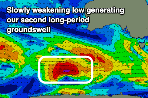
The secondary polar low formed east of Heard Island yesterday, generating a fetch of severe-gale to storm-force winds in our far swell window. The low is a little weaker now and pushing slowly east, generating a fetch of weakening severe-gale W'ly winds, and will pass under Tassie on Sunday.
We're looking at a slight upgrade in the expected size Monday with 4-5ft waves due on the Surf Coast, 6-8ft to the east but winds are still looking average and moderate from the S/SW tending S'ly owing to a high moving in slowly after Sunday's onshore change.
Tuesday is still looking much cleaner as winds swing around to the N/NE, but on the light side so it might take a little time to straighten up. Size wise, the Surf Coast should still be 3-4ft, easing with 5-6ft sets to the east. The afternoon will be bumpy with sea breezes from the E/SE.
Wednesday looks great for the exposed beaches as the swell continues to ease (3ft+ MP) with a moderate to fresh N/NE offshore, possibly holding all day.
Longer term, a small new S/SW groundswell is likely later week with favourable winds for the beaches, while a stronger low is forecast by both models to develop around the Heard Island region Sunday evening and move slowly east early next week. A moderate sized, long-period W/SW groundswell should arrive from this source next weekend, but more on this Monday. Have a great weekend!