Smaller, slow period ahead

Victoria Forecast by Craig Brokensha (issued Friday 20th September)
Best Days: Keen surfers Surf Coast later tomorrow, Surf Coast Sunday and Monday morning, exposed beaches keen surfers Thursday morning
Recap
Yesterday's large and powerful S/SW groundswell came in a bit under expectations but this opened up more locations for a surf with the swell not overpowering the Surf Coast, pumping on the beaches to 4-6ft, larger and 6-8ft+ to the east.
The swell underperformed across most of the southern states, with the low possibly a little too zonal and fast moving (because the wind strengths were there – confirmed by satellite).
The swell dropped into the afternoon and is all but gone this morning with inconsistent 2ft leftovers on the Surf Coast, 3ft to occasionally 4ft to the east if you've got the patience with northerly winds. The swell has since eased and will be totally gone by this afternoon.
Today’s Forecaster Notes are brought to you by Rip Curl
This weekend and next week (Sep 21 - 27)
With the swell fading rapidly today there’ll be nothing to surf tomorrow morning. A W/NW wind will favour the Surf Coast but it'll be tiny to flat ahead of a new inconsistent W/SW groundswell into the afternoon.
The front generating this swell has produced large and on forecast size for the Margaret River region yesterday and today, with the front since weakening while pushing further east under WA.
The swell is due to arrive into the afternoon and kick late to an inconsistent 3ft on the sets across the Surf Coast swell magnets, 4-5ft+ to the east. Winds will shift W-W/SW through the day and freshen, limiting surfing options but there'll be some OK waves for the late.
 A drop in swell is expected Sunday morning from a similar 3ft on the sets across the Surf Coast, and 4-5ft to the east with a N/NW tending NW breeze.
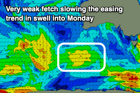
The easing trend will be slowed into early next week from a weakening fetch of W/SW winds moving through our swell window, south-west and south of WA yesterday and today, keeping inconsistent 2ft to occasionally 3ft sets hitting the Surf Coast Monday morning, 3-4ft+ to the east.
A morning W/NW wind will favour the Surf Coast, shifting SW into the afternoon with a change and persistent from the W/NW all day Tuesday but smaller and less consistent.
As touched on in Wednesday's notes, there's nothing significant on the cards for the rest of the week with the surf continuing to tail off in size and energy Wednesday and Thursday. Winds should swing N'ly on Thursday favouring more exposed beaches but we're looking at a slow 2-3ft of swell max.
Longer term, a strong polar low is forecast by ECMWF and GFS to form south-west of WA early next week, generating what looks to be a moderate sized + long-period swell for next weekend, but more on this in Monday's update. Have a great weekend!