Smaller though fun surf days to pick from

Victoria Forecast by Craig Brokensha (issued Friday 23rd August)
Best Days: Saturday, Surf Coast Sunday morning, Monday morning, Wednesday afternoon
Recap
Large, onshore and a mess across all locations yesterday, besides a few protected spots, while today all locations have become much cleaner with a NW-N/NW offshore and easing surf from the 4ft range on the Surf Coast and 6ft to the east.
Today’s Forecaster Notes are brought to you by Rip Curl
This weekend and next week (Aug 24 - 30)
Our current swell will continue to drop off into the weekend, though a mix of non-descript background swells should steady this trend tomorrow, keeping the Surf Coast magnets around 2ft to occasionally 3ft, with 4ft+ sets to the east.
It'll be windy early tomorrow but straight on the beaches with a fresh to strong N'ly breeze, shifting NW through the day ahead of a late onshore change.
 This change will be linked to a weak trough moving through, and it's been weakened even further since Wednesday.
No major swell generating fetch will occur and as a result Sunday looks to remain in a similar size range as Saturday across both coasts. A long-range and inconsistent W/SW groundswell is due into the afternoon, generated in our far swell window (southern Indian Ocean) and the models are over-forecasting the size from this swell into Sunday afternoon and Monday/Tuesday.
Instead infrequent sets pulsing between 2ft to 3ft at times are expected on the Surf Coast Sunday and Monday, 3-4ft+ range to the east and with morning W/NW winds, SW into the afternoons (holding longer Monday).
Tuesday will see the swell easing from a similar if not slightly smaller size with a persistent W/NW offshore.
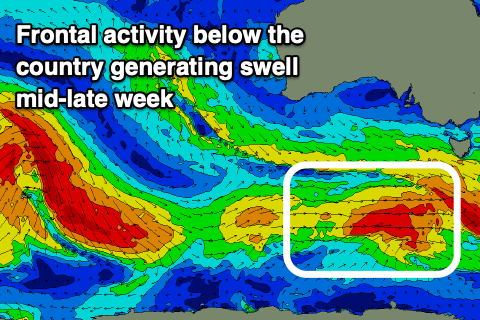
From Wednesday a mix of building long-range W/SW groundswell and closer range SW swell are due to fill in, the later produced by strengthening polar frontal activity south of the country from Sunday through most of next week.
An initial pre-frontal fetch of strong W/NW winds trailing gale-force W/SW winds continuing east under the country should produce a fun SW groundswell for Wednesday, building through the day and reaching 3ft to possibly 4ft on the Surf Coast magnets into the afternoon and 5-6ft on the Mornington Peninsula along with W/NW winds ahead of an approaching front/trough.
The trough may bring an onshore change on Thursday as the swell eases from a similar size, with more E'ly winds into Friday along with smaller surf. We'll have a closer look at this Monday. Have a great weekend!
Comments
It was a Lazy fading quickly 2ft to max 3ft tonight Craig. Still nice enough to wash work off but if it continues to fade, tomorrow will be tiny around here :(
Also, have you noticed that du Couedic now has direction? How SICK is that! I really hope Sorell will follow, that'll really change accuracy.....