A mixed bag with swells from all directions

Victoria Forecast by Craig Brokensha (issued Monday 29th July)
Best Days: Locations to the east Wednesday morning, Surf Coast Friday morning, Saturday morning, Sunday
Recap
Persistent levels of W/SW groundswell over the weekend and even into today that sat either side of 3ft on the Surf Coast and 4-6ft to the east with favourable winds for both coasts Saturday, more so the Surf Coast yesterday.
This morning the Surf Coast was the best again with NW offshore winds, though we'll see a surface trough move through this afternoon, bringing an onshore change and end to the great run of clean, fun surf.
Today’s Forecaster Notes are brought to you by Rip Curl
This week and weekend (Jul 30 – Aug 4)
After a great run of clean and fun waves on the Surf Coast (but at times to the east as well), all will come to an end this afternoon.
 A surface trough will move through bringing an onshore change and moderate to fresh S/SE winds tomorrow, lingering from the S'th into Wednesday morning. There's a chance that Phillip Island and parts of the Mornington Peninsula will see variable winds Wednesday morning, shifting SW through the day.
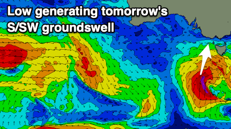
Swell wise tomorrow, we've got a mix of inconsistent and long-range W/SW groundswell with a new and better S/SW groundswell from a strong low that formed south-southwest of Tassie last night. A great fetch of severe-gale S/SW winds were generated in our southern swell window, with this being the most noticeable energy tomorrow.
The Surf Coast should kick to 3-4ft during the day at swell magnets, with 4-6ft sets to the east, easing back Wednesday from 2-3ft and 4ft+ respectively.
Thursday will be smaller again and a leftover 2ft max on the sets across the Surf Coast with a light morning W/NW offshore, bumpier and bigger to the east.
We then look towards the long-range and inconsistent W/SW groundswells due into the end of the week, and we're now expected to see some closer-range developments which will provide more size and consistency and from a better angle.
A strong frontal progression has been moving through the southern Indian Ocean since late last week, generating an inconsistent and long-range W/SW groundswell, but the remnants of this progression will continue east-southeast over the coming days.
We'll see the progression re-strengthening south of the country, with a very impressive pre-frontal fetch of severe-gale W/NW winds followed by a post-frontal gale to severe-gale W'ly fetch south-west of us on Wednesday.
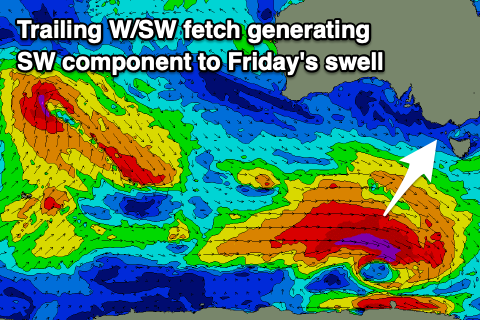 A moderate sized long-period W/SW groundswell is due to arrive late Thursday but more so overnight and peak Friday morning, with a SW component into the afternoon.
Size wise we're looking at 3ft to occasionally 4ft waves on the Surf Coast magnets, with 5-6ft sets to the east though the wind scenario has changed and we'll see W/NW tending W/SW breezes, favouring protected locations.
The swell will ease back into Saturday morning with a fresh W/NW offshore, though into the afternoon, a W/SW change will move through along with a building S/SW groundswell that will peak with size Sunday morning.
A node of the Long Wave Trough strengthening across New Zealand will provide the catalyst for a late forming polar frontal progression south-southwest of Tassie Friday, with a fetch of SW gales forming just within our southern swell window and persisting through until Saturday morning.
A moderate sized S/SW groundswell is due off this storm, building later Saturday though peaking Sunday to 3-4ft on the Surf Coast and 5-6ft on the Mornington Peninsula. Conditions look best for the Surf Coast with a NW offshore persisting all day, but we'll confirm this on Wednesday.
Longer term there's plenty more swell on the cards as a series of mid-latitude storms move in from the west, though we'll likely see a lot of varying wind as the activity moves across us. More on this Wednesday.
Comments
I had 2018 as worst winter ever. It might lose the crown.
Last year we had good conditions but no banks.
This year just mostly moderate-strong W and 6ft as a minimum and no banks really, at least down one end.
Hmm, over the last few weeks I've been sent plenty of quality videos/shots of waves working over your way Nick.. More so than last year..
Exactly
Very interesting
Pretty good winter for Westernport though. Not all time but decent none the less and August still to come which is my fav month for surf down here.
nah westernports,mud,mangroves and toadies dont bother......................
Yep pretty stock standard winter on the MP, I've had a couple fun surfs at least every week.
A few epic banks in June too. If you just stick to Portsea in winter you're going to have a bad time...
Get outta Portsea every so often bone. Been a bit around
im going to organize crowd funding for some sort or artifical breakwall or replica point break for the MP.
Surley the council could not knock it back if there is a pipe pumping out POO at rippamatta.
will call it "boners"
what conditions it work on?
can you please post the hi res winds for tomorrow morn
Here you go Willi..
10am today..

thx!
Looks like the hi-res model nailed it!