Good waves continue for the Surf Coast, larger over the weekend

Victoria Forecast by Craig Brokensha (issued Wednesday 23rd August)
Best Days: Surf Coast Thursday morning, Friday, Saturday, Sunday morning, both coasts Monday morning
Recap
Great Surf Coast waves yesterday with a new SW groundswell pulse providing 3ft sets on the reefs and beaches with all day offshores. Exposed locations to the east were bumpy, better in slightly protected spots.
Today the strongest pulse of swell has filed in with good 3-4ft sets across the Surf Coast reefs, while the Mornington Peninsula saw favourable N'ly winds early, though the surf was too big for the beaches.
We should see the swell hold all day with a late afternoon W/SW change.
This week and weekend (Aug 24 - 27)
Today's mix of long-range and inconsistent SW groundswell and mid-range W/SW swell are due to peak through today, easing off slowly into tomorrow, slowed through Friday with some reinforcing W/SW energy.
We should see the Surf Coast easing from the 3ft range tomorrow, 4-5ft on the Mornington Peninsula with an early W/NW breeze ahead of a SW change mid-morning.
Winds will revert back to the W/NW-NW Friday with an approaching front and we should see the Surf Coast hanging around 2ft to occasionally 3ft, pulsing back later in the day to a more consistent 3ft with some new W/SW swell.
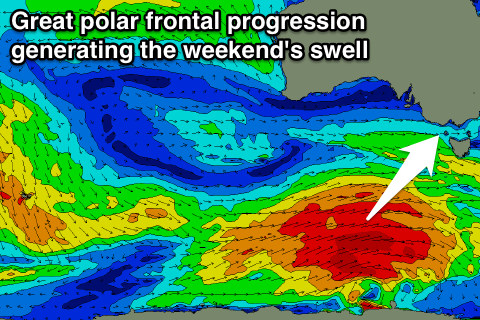 This new swell will be linked to a great pre-frontal fetch of gale-force W/NW winds moving through our western swell window today and tomorrow.
This will create a moderate sized W/SW swell building later Friday and peaking Saturday morning, ahead of a better pulse of SW groundswell Saturday/Sunday. The SW component will be produced by a much broader and elongated fetch of slightly stronger W/SW gales.
We should see larger levels of SW groundswell building through Saturday afternoon, with a peak overnight and easing trend through Sunday.
The Surf Coast should see 3-4ft sets across magnets Saturday morning, with the swell starting to build further mid-late afternoon towards the 4-5ft range (possible larger bomb sets on dark). The Mornington Peninsula should see 6ft surf Saturday morning, increasing later to 8ft on the sets.
Sunday is likely to provide plenty of size with easing 4-5ft+ sets on the Surf Coast and 6-8ft waves on the Mornington Peninsula, down slowly through the day, further Monday from 3-4ft and 6ft respectively Monday.
Our reinforcing swell for Monday will now just be in the form of a slower easing trend, with a trailing fetch of strong to gale-force W/SW winds on the back of the main progression keeping plenty of swell hitting the state.
Winds on Saturday will be great most of the day for the Surf Coast reefs with a NW tending W/NW breeze, while a shallow overnight change shouldn't stop early W/NW breezes developing again on the Surf Coast Sunday morning, S/SE through the afternoon.
More variable winds are due into Monday morning, favouring most spots. Longer term some new SW groundswell is due later Tuesday but more so Wednesday with nothing to major following this.