Fun Surf Coast waves, great over the weekend

Victoria Forecast by Craig Brokensha (issued Monday 21st August)
Best Days: Surf Coast every day, smallest tomorrow
Recap
Friday's strong S/SW groundswell held well into Saturday morning with 3-4ft waves across the Surf Coast, larger to the east, but conditions were less than ideal with winds trying to tend W'ly around Torquay but remaining more onshore than offshore.
Yesterday was much better with light offshore winds and easing surf from the 2-3ft range on the Surf Coast. The Mornington Peninsula was average during the morning, improving through the mid-late afternoon.
Today a new SW groundswell has kept the surf up around 2ft on the Surf Coast (3ft 13th Beach) while the Mornington Peninsula was fun with 4ft sets and offshore winds.
This week and weekend (Aug 22 - 27)
A secondary pulse of SW groundswell should keep wave heights around a similar size tomorrow with 2ft waves for the most part across the Surf Coast (up to 3ft at 13th Beach) while the Mornington Peninsula should see waves in the 4ft range.
Conditions will be best for the Surf Coast with a NW breeze persisting all day.
Later in the day but more so Wednesday a better mix of swells are due. A long-range but strong SW groundswell from the Heard Island region along with the remnants of the storm, projecting closer towards us while weakening, generating a closer-range W/SW swell.
We should see sets coming in around 3ft+ on the Surf Coast (though inconsistent) with 5-6ft waves on the Mornington Peninsula and a W/NW tending NW breeze will continue to favour the Surf Coast, with W/NW tending W/SW breezes as the swell slowly eases Thursday.
Now as touched on last update, we're due to see a much stronger and and favourable polar frontal progression firing up into the end of the week, generating larger and better aimed swell into the weekend.
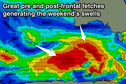 A pre-frontal fetch of gale to severe-gale W/NW winds will move in under the Bight through our western swell window Wednesday and Thursday morning, followed by a broader and better aligned polar fetch of post-frontal W/SW winds.
At this stage no size is due before dark Friday but we'll see a good W/SW groundswell Saturday morning ahead the larger SW groundswell into the mid-late afternoon, holding Sunday morning.
A reinforcing SW swell is then on the cards for Sunday afternoon and early Monday, produced by a secondary burst of W/NW gales on the backside of the polar frontal progression.
Size wise we're looking at 3-4ft sets across the Surf Coast Saturday morning with 5-6ft+ waves on the Mornington Peninsula, with the SW swell building to a better 4-5ft and 6-8ft into the late afternoon.
Sunday morning should reveal similar sized surf, dropping slightly, down from 3-4ft on the Surf Coast Monday morning and 5-6ft+ east of Melbourne Monday.
Winds Saturday look great for the Surf Coast with a W/NW breeze, similar Sunday but tending variable into the afternoon. We'll have a closer look at this and the expected size on Wednesday though.