Fun W/SW swell tomorrow, followed by S/SW energy Friday

Victoria Forecast by Craig Brokensha (issued Wednesday 16th August)
Best Days: Surf Coast Thursday, early Friday, Sunday morning, beaches early Monday, Surf Coast Monday afternoon onwards
Recap
Small clean waves across the Surf Coast most of the day in the 2ft range, with OK waves to the east as winds held from the N'th.
Today stronger offshore NW winds were blowing across the state along with small inconsistent amounts of W/SW swell hanging in around 2ft on the Surf Coast while the Mornington Peninsula was a mess. The early high tide wasn't favourable but conditions are now better and we should see a late increase in new W/SW swell across the Surf Coast, discussed below.
This week and weekend (Aug 17 - 20)
Today's strong NW winds are due to a vigorous mid-latitude front approaching from the west. The strength of this front is a little more than forecast on Monday with a good fetch of W'ly gales being projected towards us and with this a better pulse of W/SW groundswell us due later today.
The swell should hopefully reach 3-4ft by dark today on the Surf Coast, although with the late high tide which isn't great, easing from a similar size tomorrow morning, again with the early high tide.
The Mornington Peninsula should see 6ft to occasionally 8ft sets on the beaches tomorrow morning, but a fresh and gusty NW tending W/NW wind will favour the Surf Coast. Late morning looks best before the swell eases too much and the tide drops out.
The W/SW swell will continue to ease into Friday but some new S/SW groundswell will take its place.
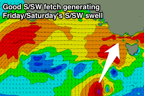 This groundswell has been brought forward a touch with a great fetch of gale to severe-gale S/SW winds forming in our southern swell window this afternoon. This fetch will move slowly east this evening and tomorrow before moving out of our swell window tomorrow afternoon.
A moderate sized S/SW groundswell will be generated, arriving Friday and providing solid 3-4ft waves across the Surf Coast along with 5-6ft surf on the Mornington Peninsula. If wind speeds come in a little stronger than forecast we may even see sets exceeding this size range on both coasts.
Unfortunately besides an early W'ly around Torquay, conditions will be poor with a SW onshore breeze.
The swell should start to ease through Saturday from the 3ft range on the Surf Coast but with onshore S/SW winds. There's a chance for early W'ly winds around Torquay again, but we'll review this Friday.
Our models are still picking up plenty of size Sunday morning, but I disagree with this, and I'm only expecting small fading 2ft waves across the Surf Coast, 4ft Mornington Peninsula with better NW tending N/NW winds.
Into early next week we've got some good new SW groundswell due followed by a better W/SW groundswell pulse Wednesday.
An initial small to moderate sized SW groundswell for Monday will be generated by a pre and post-frontal fetch of polar W/NW and W/SW gales. We should see the Surf Coast building to 3ft through the day with 4-6ft waves on the Mornington Peninsula as winds do a full 180 with an approaching low.
Early N/NE winds look to shift NW and then W/SW through the day.
A slightly better swell is expected into Tuesday afternoon, generated by a stronger polar frontal system developing in our far swell window, while a more consistent W/SW swell may be seen Wednesday, but more on this Friday.