West swells all week

Victoria Forecast by Craig Brokensha (issued Monday 14th August)
Best Days: East of Melbourne tomorrow morning, Surf Coast later in the day and Wednesday onwards
Recap
Great Surf Coast waves Saturday with a tricky but strong westerly swell coming in around my original thoughts mid-week. Good clean surf in the 4-5ft range across exposed breaks all day, with the swell easing back to 3ft yesterday morning.
The Mornington Peninsula was large and bumpy with 6-8ft sets, while better surf was seen yesterday with a bumpy buy improving 4-5ft of swell as winds tended N/NE.
This morning there wasn't any decent size left across the Surf Coast with leftover 2ft to occasionally 3ft sets on the Mornington Peninsula.
This week (Aug 15 - 18)
 We've got another tricky week of W'ly swell events across the state, as a broad and multi-centred mid-latitude low sitting off the WA coast all weekend, generating large stormy surf, moves east and across us.
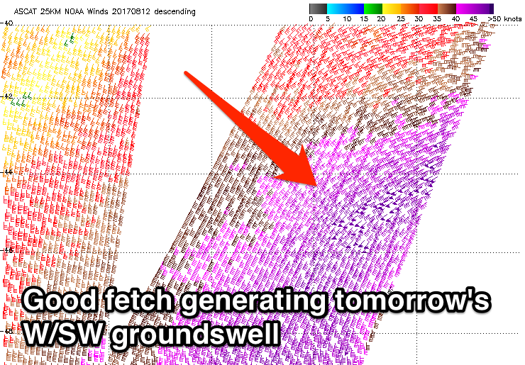
We'll see some initial inconsistent W/SW groundswell for tomorrow generated by a severe-gale to storm-force fetch of W/SW winds south-west of WA over the weekend.
This inconsistent swell should be in the water tomorrow morning, with a secondary better pulse for the afternoon.
Infrequent 2ft sets are due across the Surf Coast with 3-4ft waves on the Mornington Peninsula, increasing later to 2ft to possibly 3ft and 4-6ft respectively.
Winds will be good for exposed beaches tomorrow morning with a moderate to fresh N'ly, tending more N/NW into the afternoon, cleaning up the Surf Coast reefs.
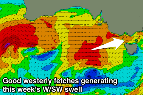 The swell should hold a similar size into Wednesday morning, but the mid-latitude storm will push in from the west, generating a fetch of strong to gale-force W'ly winds through our western swell window while pushing across us.
This should generate a moderate sized W/SW swell for later in the day and Thursday.
The Surf Coast should see sets to 3ft+ with 6ft+ waves on the Mornington Peninsula from later Wednesday through Thursday and Friday morning, as persistent W/SW fetches move through our swell window.
Winds will be offshore for the Surf Coast but poor for the Mornington Peninsula from Wednesday through the end of the week gusty W/NW breezes, slipping onshore from the W/SW-SW on the backside of the progression.
This weekend onwards (Aug 19 onwards)
The W/SW swell will start to ease into the weekend on the backside of the mid-latitude frontal progression, but we'll likely see some S/SW swell in the mix as well Saturday, generated by a fetch of strong to gale-force S/SW winds projecting up on the tail of the storm.
This swell is due later Friday and Saturday morning with 3ft sets on the Surf Coast and 5ft on the Mornington Peninsula with a morning W/NW'ly, tending W/SW through the day.
Sunday morning looks smaller, but into the afternoon and early next week some good new SW swell is due from a good polar frontal progression. More on this Wednesday.
Comments
Tomorrow afternoon's new westerly swell has been upgraded a little, we should see sets reaching 3-4ft later in the day.