Tiny week of surf with less than ideal winds
Monday, 16 December 2024
Try the East Coast for a surf.
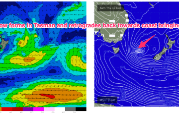
We’ll see some swell from this pattern, first from the initial short range S swell and then some better quality S/SE swell as the surface low retrogrades from near the South Island back into the Tasman.
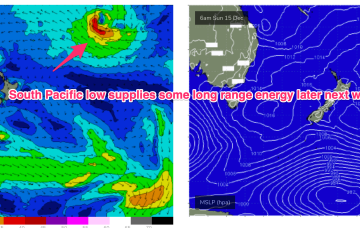
Tomorrow morning is shaping up really nicely, with a good, reinforcing W/SW groundswell for Thursday.
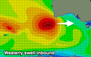
Our large westerly swell is on track with favourable winds for the Mid Coast.
We’ll see some swell from this pattern, first from the initial short range S swell and then some better quality S/SE swell as the surface low retrogrades from near the South Island back into the Tasman. Read on for details and a sketch of the Xmas week.
We’ll see some swell from this pattern, first from the initial short range S swell and then some better quality S/SE swell as the surface low retrogrades from near the South Island back into the Tasman.
A good sized westerly swell is due Wednesday but with onshore winds, improving as it eases later week.
At present these areas create weak low pressure off the CQ coast, that may see some slight E swell into the weekend.
That sets up for a solid spike in NE windswell through Mon as high pressure moves NE and a trough approaches.
Latest model runs have amplified this trough and a resulting trough of low pressure in the Tasman. There’s still some model divergence to get through so expect some revisions but odds are firming off a sizey S tending S/SE swell event from Thurs, as the trough deepens in the Central Tasman.