Average run for the South West
Wednesday, 16 October 2024

Average run for the South West
Wednesday, 16 October 2024
Perth and Mandurah will offer light morning winds as the South West enters a run of onshores.
Perth and Mandurah will offer light morning winds as the South West enters a run of onshores.
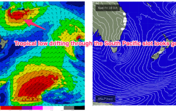
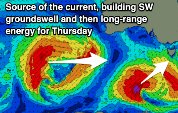
We still have low pressure roughly due east of the NSW/Victorian border buttressed by high pressure near New Zealand. It’s not a very strong system but we did see a little flare up on the southern flank o/night into this morning before the system began to dissipate, although it is expected to linger in the central Tasman
The Mid Coast will be fun most of tomorrow with variable winds, best in the morning across the South Coast.
The coming days should be ideal for the exposed beaches, though there is a chance tomorrow will be slightly too strong.
Large swell inbound with tricky winds for eastern Indonesia.
The coming outlook is slow so make the most of the building swell today and tomorrow as it fades.
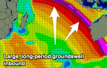
High pressure in the Tasman has maintained a better than expected tradeflow across the Coral Sea focussed SW of New Caledonia. That has seen fun waves across the weekend and we’ll see that surf pattern continue through to Wed at current levels.
We've got a peak in very strong groundswell tomorrow with light, workable winds.
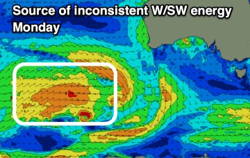
We’ve still got a dynamic week ahead as a trough currently off the Gippsland coast moves NE and develops into a broad surface low, backed by a high currently SW of Tasmania.
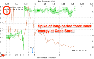
Surf now looks fun without being spectacular. A polar low passing to the south is sending long period S swells up the pipe. A modest but broad trade fetch in the Coral Sea is supplying some small E’ly tradeswell.