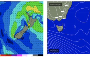
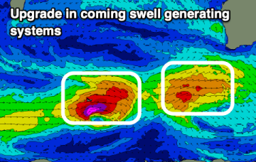
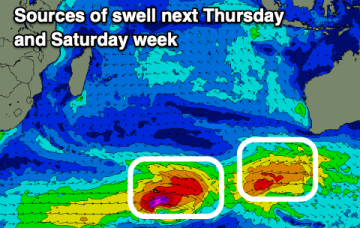
Fun sized swells with slightly better winds
Conditions should improve across the South West this period with fun pulses of swell.
Weak pressure gradients then occupy the Coral Sea through the mid week, offering up good conditions as a long range E swell makes landfall.
We'll see offshore winds develop Wed offering good conditions as a long range E swell makes landfall.
The current low located near Lord Howe Island dissipates through today with easing winds along the Eastern Seaboard as a result. Weak pressure gradients then occupy the Tasman through the mid week, offering up good conditions as a long range E swell makes landfall.
The coming week will favour the Mid Coast, cleaner Saturday down South but with a fading swell.
The current low located near Lord Howe Island dissipates through today with easing winds along the Eastern Seaboard as a result. Weak pressure gradients then occupy the Tasman through the mid week, offering up good conditions as a long range E swell makes landfall.
The coming period is tricky with a mix of different swells and varying winds so you'll need to be on it.
Through Mon we’ll see a slow building trend from the E/SE as swells fill in from a tropical depression drifting south from Fiji.
A low is expected to move E of Tasmania o/night and form a broad low pressure trough in the Tasman driving SW’ly then S’ly winds up the Tasmanian east coast before moving NE as a surface low over the weekend. That will be the second surface low in succession to form in the Tasman and we may yet see a third develop later next week.
A low is expected to move E of Tasmania o/night and form a broad low pressure trough in the Tasman driving N-NW’ly then S’ly winds up the coast before moving NE as a surface low over the weekend. That will be the second surface low in succession to form in the Tasman and we may yet see a third develop later next week.