Big week of waves ahead
Sydney Hunter Illawarra Surf Forecast by James Casey (issued Monday 24th May)
Best Days: Tuesday, Wednesday, Friday and windy but big for the weekend
Outlook:
- Larger E swell from Tuesday onwards, ebbing and pulsing until Friday
- Pulse of E/SE swell and new S swell building on Friday
- Large S swell for the weekend peaking on Saturday and then again on Sunday late/Monday early
- Conditions to ease from Tuesday onwards
Recap
A mostly small weekend of waves starting out of the S and becoming more SE as the weekend went on. Conditions were best early with light offshore winds before they tended out of the S each afternoon making things a bit bumpier.
Today we have a peaky 2ft E swell with light winds early although winds will turn around to the NE later this afternoon.
This week
Well have a week of serious surf on the cards. A solid E swell from the low pressure system north of NZ has already been generated and is heading our way. While it isn’t aimed all that well for S NSW we will still see solid surf. Later in the week we will see another solid S pulse arriving thanks to yet another low located west of the South Island.
The E swell will arrive overnight but build into the afternoon with a widespread 4-5ft expected. The swell will rise fairly rapidly thanks to the gale force winds on the southwestern flank of the low north of NZ.
It will then be sustained by a SE swell thanks to SE winds funnelling out of the Cook Strait on the southeastern flank of the low. This means we will see the swell pulse and ebb throughout the week but generally remain around that 4ft+ mark. After the peak on Tuesday afternoon we will see some slight easing on Wednesday into Thursday with waves down around the 3-4ft mark before another E/SE pulse arrives early on Friday bumping wave heights back up around 3-5ft with a new S swell building throughout the day.
Winds will be fairly strong out of the N tomorrow (Tuesday), starting NW early but tending NE and strengthening in the afternoon. Wednesday will see strong NW winds early shifting more W as the day goes on while Thursday has W/SW winds for most of the day. Friday will be the windiest day with SW winds early strengthening out of S/SW by the middle of the day.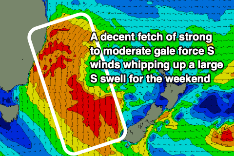
The weekend and beyond
The new S swell will really ramp up late on Friday into Saturday morning as a low forms to the west of NZ and squeezes the isobars on a ridge in the Tasman.
Strong to moderate gales will whip up a solid S swell peaking around 8-10ft on Saturday before easing a bit into Sunday morning. WInds will be strong out of the S/SW so southern corners will be your only option.
Another pulse of S/SE swell will arrive on Sunday afternoon/Monday morning ramping wave heights back up towards 6-8ft although once again winds will be strong out of the S/SW.
The low will start to breakdown on Monday as it moves over NZ allowing conditions to begin to ease into the start of the new week. A high looks to move over the east coast bringing lighter winds and generally more settled conditions from Tuesday onwards.
Comments
Yippee yahoo now thats a surf report I like reading.
According to the models atm 15 to 18 foot Saturday morning for the Illawarra. Surely that is a gee-up?
You beauty, we’re holding a surf comp on Sunday it’s going to pump!!! Been waiting for this for a while.
Does it look like the swell is early or is it still expected to keep building into the arvo?
Looks early, probably peaking this AM.
Why do you reckon the early timing? Possibly because the period is stronger than the model forecast (and hence quicker travel time) or do you think the system just developed across the cook strait earlier?
I was going to go for a paddle this morning expecting to bring my small wave twinny for a couple of inco 2-3footers, ha! Glad I slept in instead as looks like it started maxing pretty quickly.
Looks like the forecast was spot on for NNSW/SEQ though.
Yeah rapid intensification of the low and that long period energy racing in across the Tasman Sea. Usually happens with these systems within our swell window, the bulk of swell arrives with the peak in period instead of the lag seen in the southern states.
Well explained, thanks Craig.
Craig, the Swellnet modelling shows an increase in size and period tomorrow (Wednesday) morning.
Other sites showing a decrease in both...what do you reckon??
It'll be easing, models are mixing up the long-period energy and shorter-period energy.
Ok, I'll go with that.
Your models though are showing a big jump in long period intensity, approx increase of 2.2s which I would equate to an increase in size by 4 ft or so.
I know there is a limit to what technology can predict but that's a pretty big discrepancy to the reality
Hmm, I can't see it, just steady 11s?
I should have taken a screenshot but your model said 1.4m at 9.3s 6pm Tues, 1.5 at 11.8 6am Wed very similar direction, slightly more to the south by a couple of degrees.That’s a big increase, in my mind that would equate to 2-4ft bigger but obviously it’s smaller this morning.
Don’t know whether you can tweak the technology or just note that it was wrong this morning
Agh, yep that's that mixing of swell and the model struggling to resolve the incoming energy, as it did with yesterday's large, long period pulse.
There's a new mid-period pulse due late afternoon today and again later tomorrow ahead of the tricky groundswell late Friday.
No drama this morning but I’m frequently on the dawn patrol and aim to be the first guy in the water. The prediction helps with the pre-dawn choice of spot...other website(s) I think are more accurate for that info but don’t have forecaster notes or comments.
No real complaint but the feedback might help you tweak the technology
Yep, thanks Tyler.
punched welllll above forecast around wollongong
It was bigger than anticipated, but a few fun ones out there.
There was signs yesterday arvo .. good shape fun ones .. was expecting a slow building swell today.. big surprise. No takers at my local today.. especially when NE wind kicked in .. better conditions ahead forecasted..
Shark island cam was so sick to watch this morning some absolute insanity goin on
Early Tuesday my local point had very thick 6-8ft bombs and the Island
standing up even bigger. Caught me out after planning my work around
a 3ft day. Not complaining just needed some quick adjustment.
Has anyone got the footage of when mason and mick surfed south of the gong
Found it dw
Are you trying to redirect potential crowds away from your local for the coming swells?
Give them a sniff of potential and let them flock away? I like it, keep up the good work.
With one caveat ... the stragglers will descend upon the surrounding breaks less capable of holding a big crowd.