South followed by west
Monday, 14 October 2024
South followed by west
Monday, 14 October 2024
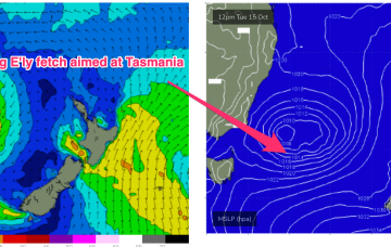
A fun southerly groundswell is due tomorrow followed by west Wednesday/Thursday as winds generally favour the Mid Coast.
A fun southerly groundswell is due tomorrow followed by west Wednesday/Thursday as winds generally favour the Mid Coast.
Overall though, the surf potential has been toned down as windspeeds remain limiting and the system dissipates as it lingers in the Tasman. Local winds also take a couple of days to improve.
Winds out of the north-eastern quadrant will favour locations to the east but there'll be a couple of sizey swells to deal with.
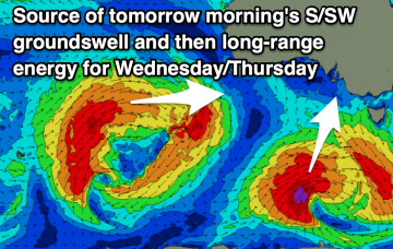
Some decent sized swell is due tomorrow with tricky winds, cleaner and easing Sunday.
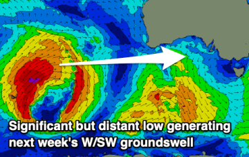
We’ll see surf build on Mon as the next high pressure surge builds and extend into most of next week under SE-E winds.
Poor tomorrow, good Sunday and then XL next week with an improved wind outlook.
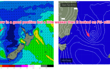
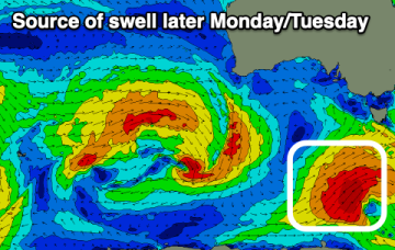
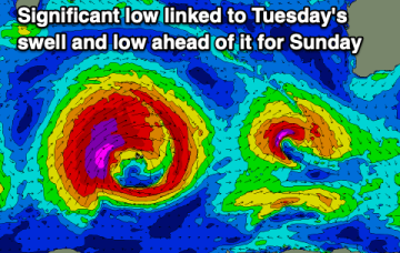
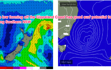
The trough looks to rapidly deepen into a broad surface low off the Far South or Gippsland Coast o/night Mon into Tues. There’s still model divergence over the strength and position of this low which will have material impacts on surf size and local winds so stay tuned for updates over the weekend and on Mon.
We have a broad front passing into the Tasman and a northwards moving trough, with a high pressure ridge filling in behind those short range features. The front will supply workable levels of S swell Sun but winds will be a problem with a a mod/fresh S’ly flow, tending SE’ly- E’ly during the day.
Swells with a bit of west in their direction continue to favour the Mid Coast.
The trough looks to rapidly deepen into a broad surface low off the Far South or Gippsland Coast o/night Mon into Tues. There’s still model divergence over the strength and position of this low which will have material impacts on surf size and local winds so stay tuned for updates over the weekend and on Mon.