South, south, south

Sydney, Hunter and Illawarra Surf Forecast by Craig Brokensha (issued Monday 15th July)
Best Days: Every day this period until Sunday, though cleanest across those south magnets from Wednesday
Recap
As flat as it gets on Saturday with a tiny wave in the morning being blown flat by strong offshore W'ly winds as a cold front pushed across and off the southern NSW coast.
This front generated a pulse of new S'ly swell on Sunday that performed best north of Sydney, due to the local nature of its source being off the southern NSW coast. The Central Coast kicked to 4ft with improving winds, 4-5ft up around Newcastle, but Sydney failed to really budge above 2-3ft, easing later.
This morning we fell in between fronts and swell pulses, with the next strong front pushing up the southern NSW coast last night and early this morning. This was a little better aligned for swell generation for the South Coast, but still not great, with the swell now filling in across Sydney. The buoy readings aren't too impressive though and it's not at the 6-8ft expected by Ben, though a peak is due this afternoon. Looking at the fetch currently it's more than likely we'll see Sydney's south facing beaches peaking around 4-6ft this afternoon, larger in the Hunter and smaller on the South Coast.
Today’s Forecaster Notes are brought to you by Rip Curl
This week and weekend (Jul 16 - 21)
These notes will be brief as Ben’s on annual leave.
This week will consistent of multiple S'ly swell pulses, some groundswell others mid-period energy and all better aligned and more favourable than the swell seen yesterday and today.
This afternoon's pulse of size is expected to ease back into tomorrow morning but a secondary strong front, though boarder in scope and positioned more east into the Tasman Sea will push up through our swell window tomorrow.
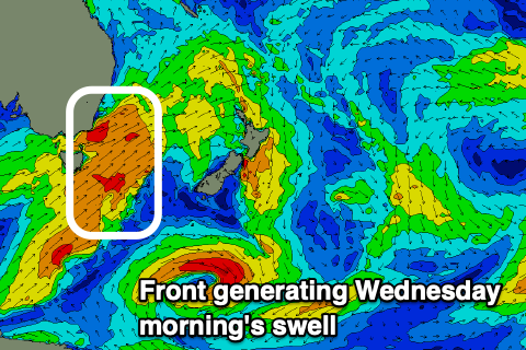 A moderate to large S'ly groundswell is expected from this front, arriving late in the day bur more so Wednesday morning. Therefore we'll likely see waves around 3-5ft most of tomorrow from a trailing fetch in the wake of today's front (smaller South Coast and bigger on the Hunter), possibly increasing a little through the afternoon with Wednesday's pulse coming in at 4-6ft, bigger across the Hunter, easing slowly through the afternoon, smaller into early Thursday.
Winds will be good but not great and fresh offshore out of the W/SW tomorrow morning, weaker S'ly into the afternoon creating bumpy conditions, with Wednesday looking great across those south magnets with a moderate W/NW offshore, shifting W/SW through the afternoon.
Thursday morning looks clean again with a straight W'ly offshore, variable if not weak sea breezey into the afternoon.
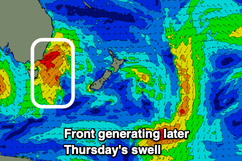 A new S'ly groundswell is due to build into Thursday afternoon as winds go variable as a strong front pushes off the southern NSW coast during the early morning. This may limit the size a little down in that region, but we should see south facing beaches kick back to 4-5ft+ in Sydney by late in the day, bigger across the Hunter, then easing from 3-4ft Friday morning with a W/NW tending variable breeze.
Moving into the weekend we'll continue to see cold fronts moving through our southern swell window but on a more west to east zonal track, resulting in less size for us, especially on the South Coast, with the Sydney and Hunter regions fairing best.
A front exiting Eastern Bass Strait Friday will produce a mid-period S'ly swell for Saturday morning to 3ft across south swell magnets, tiny elsewhere, easing through the day, with a smaller swell Sunday to 2-3ft, fading through the day. Winds look to remain favourable for south facing beaches with a W/NW offshore ahead of N/NE sea breezes Saturday, and all day offshore NW breeze Sunday.
Longer term there's nothing too significant on the charts for most of next week, so make the most of the coming southerly swell pulses and clean conditions.
Comments
the models have been on drugs lately
Yeah, it's a tricky one when they combine the local winds and swells and also struggle with the direction (more up along the coast rather than into it). Hence the Forecaster Notes become of more value.
Geez , I’ve got no confidence at all in tomorrow judging by the 1ftrs on the Bondi cam right now what’s happened to the nearly
3mtrs @ 11 sec that’s been forecast for late this arvo that’s been on the graph most of the day?? Just wondering Craig If your Still expecting 3-5 ft tomorrow After todays underperforming swell has all but disappeared?
Hopefully, there was a decent trailing fetch behind this morning's push, would be confident on 3-4ft, fingers crossed.
Northern beaches sth facing was easy 4ft on the sets this arvo and cleaned up nicely for the sunset session.
Thanks Simon, good to hear!
I’ve really gotta learn to be more optimistic, first light and there it is , nice little lines outa the south. Good call Craig !
Thanks Onenut. Always a tricky call when the swell the day before doesn't reach the expectations and you've got to not try and over-react and drop the forecast too much for the following day. Looks really fun out there.
didn't see any 4ft this morning, only slow 2 footers shores at curly
Big bigger than 2ft Maka.. More so 3ft+
Good call again. Thanks. Definitely some 4 footers up towards the Hunter region.
Think I might have to move to Margaret River... 3ft... 4ft.. Bungan was all straight-handers this morning. Cummon huey!!
Perfectly called again. Gold Star.
Thanks, though I'd give it a silver, looks like Sydney is more around 4ft, than 4-6ft. What size did you surf and what region roughly?
Yep I'd say it was 4ft in Sydney although I saw two cleanups that punched above this - they were perfectly formed too.
Can't complain about the good run of swell, but it's frustrating to have these beautifully groomed lines of groundswell falling on straighhanders. This morning wasn't too bad but yesterday morning was closeouts galore (and smaller than hoped). Need just a tad more E for it to fill in better.
I'd have called it a slow 3-4ft where I surfed (somewhere in the pittwater area, without being too specific)... bit wobbly/morning-sick-y too coming up to high tide.
Wouldn't be surprised if it was a shade bigger elsewhere though.