Fun small waves for a few days, then a building E/NE swell

Sydney, Hunter and Illawarra Surf Forecast by Ben Matson (issued Friday 12th April)
Best Days: Most days should have fun small waves with mainly light winds.
Recap: Our mid-week round of short range south swell eased through Thursday but we’ve seen a small, inconsistent new S’ly swell build to 2-3ft across south facing beaches today, though it's tiny elsewhere. Winds have been light both days so conditions have been clean.
This weekend (April 13 - 14)
Today’s Forecaster Notes are brought to you by Rip Curl
No change to the weekend forecast. We’ll be under a weak troughy pattern, and therefore light winds and generally clean conditions.
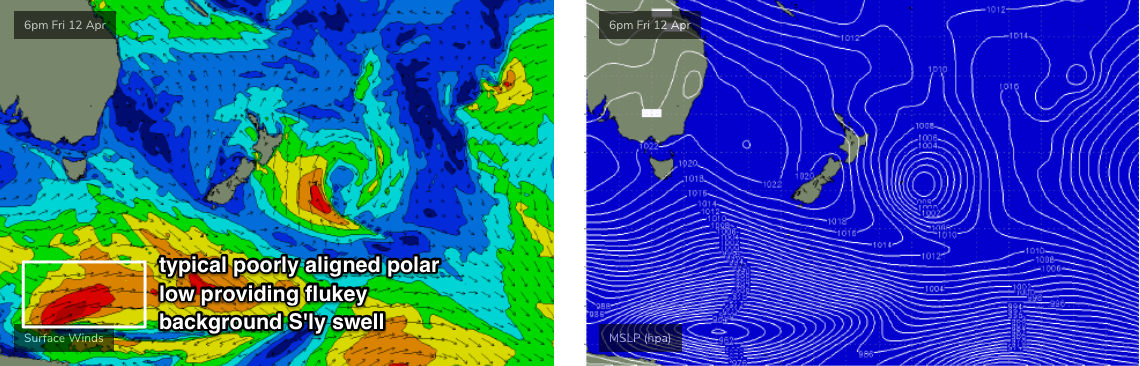
The only source of swell for the weekend will be a small, intermittent supply of long range southerly groundswell, generated by migrating polar lows along the ice shelf this week, well south of the continent in our remote south swell window.
Most beaches will be lucky to see a rideable wave at all, but south swell magnets should pick up occasional 2-3ft sets at times both days. However there’ll very long breaks between the sets.
If anything, Saturday may see a smidge more size than Sunday but on the balance I don’t think there’s much in it.
Next week (April 15 onwards)
No major changes to the long term outlook either.
We’re looking at continuing small swells for the first half of next week, just minor energy generated by flukey systems on the peripheries of our swell windows. There’s a couple of small interesting troughs expected to occupy the southern Tasman Sea but I don’t they’ll amount to much. Otherwise there'll be small background S'ly swells from poorly aligned polar lows (see chart below).
No major synoptic influence is expected locally Monday and Tuesday under the continuing troughy pattern, so expect generally clean conditions with light winds.
A broad Tasman high pressure system will develop mid-week, and strengthen a broad ridge to the north, between it and a region of local pressure occupying the Tropical South Pacific and Coral Sea. This feature will remain slow moving for quite a few days - all the way through Easter in fact - and so we’re looking at long lived E/NE swell event for the entire East Coast, including Southern NSW.
The early stages of this swell should start to show Wednesday, though no major size is expected. In fact, although there’s some model guidance suggesting a large swell event for the Easter break, I don’t think we’ll see any lofty wave heights through Southern NSW; the ridge is expected to max out at 30kts though its broad coverage should ensure a fully developed sea state, which should punch wave heights higher than modelled.
As such, I’m expecting a gradual building trend from Thursday through Good Friday and Easter Saturday, probably peaking Easter Sunday around 3-4ft+ at most open beaches. The slow moving ridge should however help to boost the consistency of the swell, which is a bonus.
Local winds may freshen from the north for a few days as a front approaches from the west (centered around Thursday) but otherwise we’re looking at quite a few days of light winds and therefore good beachbreak conditions from around Wednesday thru' Monday.
There’s a lot of funky activity on the long range charts (beyond Easter) that I’m not willing to speculate on, as the models are already not completely in sync at the moment. Nevertheless, there’s plenty to look forward in Monday’s notes.
Have a great weekend!
Comments
Typical, what else would you expect from a polar low suffering poor alignment!
there were some decent sets coming through this arvo, every bit of 3 ft.
boo!
Ben, why recap?.
Whaddya mean?
Easter usually delivers,fri morning everywhere busy,fri arvo,most people busy Fri arvo with drinking and family. Sat morning usually minimal crowds cuz of hangovers etc. Sunday is usually another reasonably uncrowded morning! Iv had many uncrowded sessions over Easter the last 20 years or so,just gotta stay off the sauce!
Big disparity in wave height across this neck of the woods this arvo Ben. Sth end beaches small. I went for a long wander further up the beach and sets were well Nth of 3ft, strongish, long and fairly consistent. Banks not so hot.
Happy Easter all.
Very odd. Which coast mate?
Nulla
Why do you bother recapping in your report?. It’s done n dusted.
Recap is very important.
Firstly, it allows me to discuss what happened over the last few days - whether the previous forecast was right or wrong, and to discuss the variation in surf conditions across the region. Sometimes there’s not much to report, other times there’s a wealth of fascinating data. This is also valuable information when hindcasting swell events - we can look back at all of the observational data but also see a written summary from the relevant forecaster whose spent the most time looking at the corresponding weather charts around that time.
Secondly, it sets a datum for the following forecast period. If I state in the recap that today’s south swell was 3ft, and the forecast for next few days is 4ft, then - even if you disagree with my size reference/scale - you know I’m expecting more size than today.
etc.
Thanks for detailed reports mate. More often than not its pretty spot on for my section of the coast down south.
Strong 3ft sets this morning, plenty of power. Started to slow and fade with the tide change.
Newy forecast.
Nothing worth while until weekend 20th-21st which will see 2ft max of E/NE swell at around 10 sec at exposed locations. Slight potential for fun waves at a good bank.
Any chance on the daily reports you can just post the conditions without telling people which bank or reef to aim for? Let them work it out for themselves instead of leading them to the spots that usually fair pretty well with crowds.