Small out of the south, ahead of a tasty Easter break

Sydney, Hunter and Illawarra Surf Forecast by Ben Matson (issued Wednesday 10th April)
Best Days: Most days: mix of small S'ly swells with light winds. Next Tues onwards: building E'ly tending E/NE swells, biggest through the Easter period.
Recap: Small, easing swells and light offshore winds for most of Tuesday were replaced by a mid-afternoon gusty S’ly change (arriving 3pm at North Head) that built S’ly windswells into the 3-4ft range this morning at south swell magnets, though wave heights were much smaller elsewhere due to the swell direction. We’ve seen isolated patches of early SW winds today, though it's otherwise been generally fresh S’ly.
This week (April 11 - 12)
Today’s Forecaster Notes are brought to you by Rip Curl
Today’s gusty winds will ease back and become light and variable for the rest of the week. We’ll see weak sea breezes in the afternoons too.
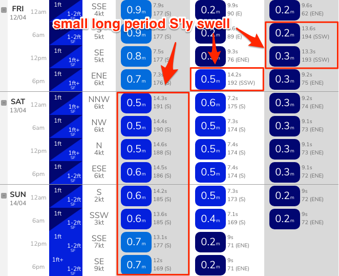
No major surf is expected for the next few days. Today’s S’ly swell will ease steadily into Thursday, ahead of a small pulse of S’ly groundswell on Friday, from a polar low skirting the ice shelf over the last few days. Wave heights will be only small from this source, but south swell magnets may pick up stray 2ft, almost 2-3ft sets (though there’ll be long breaks of tiny conditions between waves). Elsewhere expect very small surf.
This weekend (April 13 - 14)
Light winds are expected all weekend under a weak, troughy synoptic pattern. As such surface conditions should be nice and clean both days.
Once again, no major swell events are expected however we should see small waves at south facing beaches both days, originating from migrating polar lows along the ice shelf this week, well south of the continent, in our acute, remote south swell window.
At this stage there’s no confidence in any timing for the swell phases, so keep your expectations low. South facing beaches should see extremely inconsistent 2-3ft sets both days, but surf size will remain very small elsewhere.
Next week (April 15 onwards)
No major changes to the long term outlook.
The start of next week looks similarly small with minor flukey south swells for exposed beaches, but we’ll see our east and north-east swell windows slowly develop, thanks to the interaction between a coastal trough, a large, stationary high in the Tasman Sea and a broad region of low pressure through the eastern Coral Sea into the Tropical South Pacific (from about New Caledonia through Fijian longitudes).
This is expected to slowly develop a wide easterly fetch that looks like generating solid surf for northern regions over the Eastern break, with smaller but very fun E/NE swells for Southern NSW.
Prior to this, we’ll see a small mid-week increase in E’ly swell Tues/Wed from a minor but related fetch in the central Tasman Sea. However the main event won’t kick in until the holiday break.
There's also a suggestion for a small Tasman Low in our mid-range SE swell window around Good Friday and Easter Saturday too, which is of equal interest as a punchy swell source for Sat/Sun/Mon.
More on this in Friday’s update.
Comments
Oh man. We are getting another year of hell
Is it just me or are we getn into some sort of record territory for the longest average run of dog turd waves ?? Would be interested to see the stats over the last 2 years for the east coast. It’s been a long long time since we’ve seen any substantial swell (6ft+) coincide with favourable winds. Not saying it hasn’t happened briefly somewhere for someone though