Light winds and flukey swell sources for quite some time

Sydney, Hunter and Illawarra Surf Forecast by Ben Matson (issued Monday 1st April)
Best Days: Tues: intermittent S'ly swell at south facing beaches. Wed onwards: small building E/NE swell, easing Fri, rebuilding Sat. Sun: small/mod, long period E/NE swell, easing Mon.
Recap: What a weekend! Saturday delivered fantastic short range NE swells with offshore winds, size up to 4ft+ at exposed beaches and epic sessions reported the length of the coast. Sunday’s building S’ly groundswell delivered a wide range in size, and conditions were super clean all day. Most locations peaked into the afternoon, some not until the last hour or so before dusk, and some coasts did very well whilst others didn’t pick up quite as much size as expected. Reports came in ranging from 8-10ft at one of the state’s more reliable south swell magnet bombies, down to 4-6ft across south facing beaches in the Illawarra, and 5-6ft+ across parts of the Hunter region. Most south facing beaches along the Northern Beaches only managed 4ft through the afternoon (with much smaller surf elsewhere), but a couple of spots did nudge the 5ft mark. Today’s seen a similar round of southerly groundswell without the upper size range extremes, most south facing beaches coming in around 4-5ft though the Northern Beaches have again under-performed compared to other coasts. Winds were offshore early but swung S’ly around lunchtime.
This week (April 2 - 5)
Today’s Forecaster Notes are brought to you by Rip Curl
There’s actually another southerly swell filling in across the South Coast this afternoon that’ll provide surf into Tuesday.
A deep polar low formed off the ice shelf well south of Tasmania over thew weekend, and satellite data picked up a 50kt fetch around its core, aimed within an acute but definite part of our remote south swell window. The models have pegged this at 0.4m at 17.2 seconds for tomorrow, but I am concerned by the large travel distance - it’ll result in some seriously inconsistent sets at times, and between then you’ll be fighting for 2ft+ leftovers from today’s south swell plus a small building E/NE swell of a similar size. Conditions look good with light variable winds and sea breezes.
How big will this south swell reach? As per Sunday’s pulse, which resulted in an enormous range in size between even more traditionally reliable south swell magnets, we could see 4-5ft sets at some locations, but only 2-3ft at others. It’s really going to be another classic example of magic numbers: some beaches will light up well and others won’t. So, don’t despair if you’re favourite south swell magnet isn’t picking up all of the size, as there could be a different result around the corner.
Wednesday will see this south swell disappear quickly, and the distant E/NE swell will reach a plateau. It was generated by a broad E’ly fetch north of New Zealand late last week, and we’ll see inconsistent 3ft sets at the height of the swell through Wednesday afternoon and Thursday. Light winds will persist.
Otherwise, the only swell source for this week is some small sideband E’ly energy from a strengthening right across the northern Tasman Sea. No major size is expected but there’ll be peaky 2ft sets from this source between the long range E/NE energy, building concurrently Wednesday then easing later Thursday.
Similar conditions are expected on Friday with a slight drop in size from all sources.
This weekend (April 6 - 7)
Nothing amazing is expected this weekend, though we will see fun waves both days.
A small E’ly dip developing in the north-eastern Tasman Sea on Thursday will move westwards through swell window on Friday. No major strength is expected within the fetch but the westerly push is a good thing, and should rebound wave heights a little into Saturday, with 2-3ft sets at most open beaches.
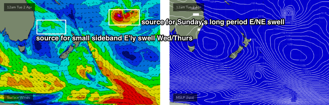
During the afternoon, the leading edge of a distant long period E/NE swell will make landfall, generated by an intense sub-tropical low developing well SE of Samoa at the moment (see chart below). It’s an incredible looking system, except it’s unfortunately positioned an enormous distance form the coast and this will significantly cap surf size. However we should see peak swell periods draw out to 16-17 seconds, and this should create occasional 3-4ft_ sets at exposed beaches, though there could be twenty minutes or more between ‘em.
As for local conditions, early morning winds are expected to be light under a troughy pattern but we will probably see freshening N’lies each afternoon.
Next week (April 8 onwards)
Nothing major for the long term at this stage, with easing long period E/NE swell expected Monday and a possible series of strong fronts below Tasmania and associated southerly groundswells mid-next week.
More on that in Wednesday’s update.