Continuous diet of S'ly swell

Sydney, Hunter and Illawarra Surf Forecast by Craig Brokensha (issued Friday 15th September)
Best Days: South magnets Saturday morning, open beaches Sunday, south magnets Monday and early Tuesday
Recap
Building S'ly swell through yesterday with sets hitting 3ft at south facing beaches with blustery offshore winds.
This morning the swell was coming in at 3ft+ with offshore winds, though there was a wait for the bigger ones. We've got some stronger swell out on the coast this afternoon though with slightly bigger 3ft to occasionally 4ft sets at south magnets with offshore winds.
This weekend and next week (Sep 16 – 22)
These notes will be brief as Ben’s away today.
This afternoon's stronger kick in S'ly groundswell was generated by the strongest fetch of W/SW gales exiting eastern Bass Strait yesterday afternoon and evening.
The fetch was still present this morning, slowly weakening through today and moving away from our swell window.
This will result in fun levels of S'ly swell persisting at south magnets tomorrow morning, easing from 2-3ft in Sydney, with larger sets across the Hunter early.
We'll see another strong cold front push up the southern NSW cast through the day, possibly bringing a late increase in new swell, but morning offshore W/NW winds will give into a gusty S'ly change, creating average conditions.
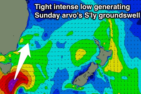 Now, this front will generate some new mid-period S'ly swell for Sunday, building towards a peak into the afternoon, but there'll also be a long-period and stronger S'ly groundswell in the mix.
The source of this swell will be a very tight and intense mid-latitude pushing under Tasmania, producing a fetch of severe-gale to storm-force SW tending S/SW winds through our southern swell window tomorrow morning.
Early morning, south facing beaches are expected to be around 3ft+ or so, but we should see the groundswell and mid-period swell jumping to a solid 5-6ft through the late morning/early afternoon.
The Hunter is likely to offer 3-4ft waves through the morning and 6ft+ sets into the afternoon.
Conditions will be clean across open beaches and a little bumpy at south magnets Sunday morning with a W/SW breeze, swinging S'ly through the day and SE into the afternoon.
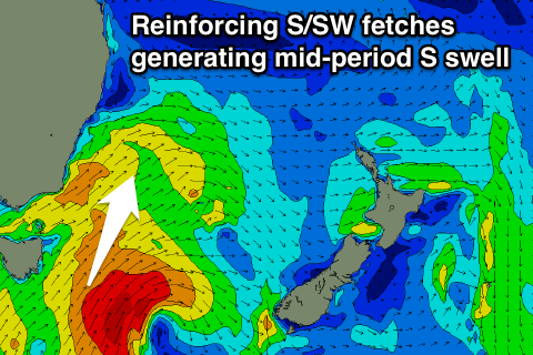
Both swells should ease into Monday, with the mid-period energy being the most dominant, slowed by the cold-outbreak making its way slowly north-east towards New Zealand Sunday, out of our swell window Monday.
A slight tweak in the direction to the S/SE should be seen, with sets easing steadily from 3-5ft across south magnets early (4-5ft+ Hunter).
 Conditions will be great for south facing spots with a morning N/NW breeze, tending N/NE into the afternoon.
A small pulse of NE windswell is likely Tuesday morning as a northerly fetch strengthens overnight, with 2ft sets likely across north-east facing beaches, fading as a S'ly change approaches into the afternoon.
There'll also be easing amounts of S/SE swell from 2ft+ at south magnets.
This S'ly change is due to bring with it a moderate sized increase in S'ly windswell Wednesday but with poor winds, smaller, cleaner and easing Thursday.
More on this Monday though. Have a great weekend!
Comments
Nice S'ly lines across the Manly stretch this AM:
Nice slab at the Island.