Back to back S'ly groundswell pulses
Wednesday, 27 July 2016

Back to back S'ly groundswell pulses
Wednesday, 27 July 2016
Not shortage of S'ly swell to come with good offshore breezes.
Not shortage of S'ly swell to come with good offshore breezes.
Mix of swells tomorrow, smaller into Friday under W/NW winds. New SW swell for Saturday morning with N'ly winds, easing Sunday. Plenty of swell for next week from the W/SW.
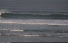
Today saw very strong lines of S’ly swell in Southern NSW, and because of the origin, direction and trend, we can be reasonably confident that this swell will push across Northern NSW too.
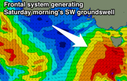
The rest of the week is quite complex, with a series of back-to-back frontal systems expected to generate varying degrees of south swell.
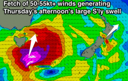
Easing S/SE swell tomorrow, tiny until a strong new S'ly groundswell fills in Thursday afternoon.
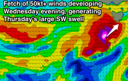
Large W/SW swell building tomorrow, easing Wednesday, ahead of a stronger SW swell Thursday morning, smaller into the end of the week.
Large long-period S/SW groundswell for tomorrow but with onshores in the South West, cleaner to the north. Better cleaner waves Wednesday and Thursday. Large building swells from the weekend but with terrible conditions.
Large SW groundswell for tomorrow morning with decent winds for protected spots most of the day, onshore and still large Wednesday morning, cleaning up late. Clean and fun from Thursday down South with average Mid Coast waves the whole period.
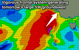
Large powerful W/SW groundswell filling in tomorrow, easing slowly Wednesday as longer-period energy fills in, smaller into the end of the week. Excellent conditions developing across the Surf Coast tomorrow, average most of Wednesday, then clean again from Thursday.
This means we won’t see the resulting new southerly swell push up the Northern NSW coast until sometime Sunday - probably early to mid morning on the Mid North Coast, then early to mid afternoon across the Far North Coast.