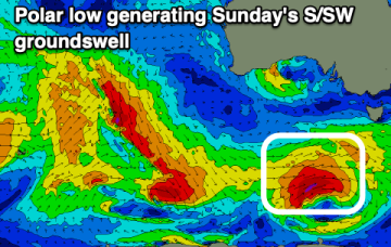
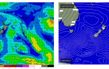
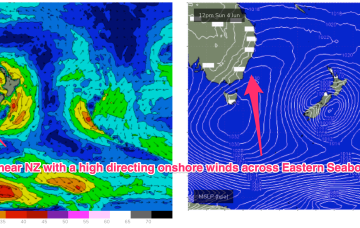
S pulse Sun before NE windswell builds Tues next week
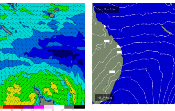
NE winds developing off the South Coast down to Bass Strait look like generating some useful NE windswell next week.
The wind outlook for Sunday has improved with a final, strong groundswell.
A new inconsistent swell with favourable winds is due tomorrow ahead of onshore breezes and oversized, stormy developing swell.
A front pushing aggressively NE into the lower Tasman on the weekend forms a low pressure centre which becomes slow moving near New Zealand early next week and this will be a co-main swell source for the week. The other source will be short range, peaky E’ly swell from a tradewind style fetch in the Southern Coral Sea.
We've got a slower period of activity following Sunday's S/SW groundswell with the surf bottoming out through next week.
A front pushing aggressively NE into the lower Tasman on the weekend forms a low pressure centre which becomes slow moving near New Zealand early next week and this will be our dominant swell source for the week.
We've got a shift in weather patterns which will see the groundswells fading along with winds out of the north-eastern quadrant in general.
No great change to the f/cast with a high pressure ridge already building across the QLD coast and set to be reinforced by a much, stronger high which moves SE of Tasmania (summer latitudes) over the weekend.
Another powerful front with gales to severe gales pushes NE into the Tasman Sat into Sun with a strong pulse of S swell making landfall across NETas at S facing beaches on Sun.
No great change to the current pattern with a large high sitting very far up (right up on the QLD/NSW border!) allowing free passage for cold fronts into the lower Tasman and a generally synoptic W’ly flow to continue across the region. Mostly long period S swell trains will continue to the be the dominant swell source until next week when a much more S’ly located high brings an onshore flow to most of the Eastern Seaboard. A trough of low pressure looks to briefly form off the Mid North Coast early next week before moving away quickly.