Fun options for the weekend and early next week

South Australian Surf Forecast by Craig Brokensha (issued Friday October 14th)
Best Days: Mid Coast from mid-late morning tomorrow, South Coast tomorrow, South Coast Sunday morning, South Coast Monday and Tuesday mornings, Mid Coast for the keen Monday
Features of the Forecast (tl;dr)
- Mix of easing W/SW swell and new SW groundswell tomorrow with N/NW tending NW winds down South ahead of a late PM S/SW change. Light-mod W/NW tending lighter N/NW winds on the Mid, SW into the PM
- Mix of small swells Sun with N/NW tending S winds down South, E/NE tending S/SW on the Mid
- Mix of moderate sized S/SW and SW groundswells Mon with mod-fresh N/NE-NE tending E/SE winds down South, E/NE tending SE on the Mid
- Easing surf Tue with fresh N/NE-NE tending E winds
- Smaller Wed with fresh E/SE-SE winds, fresh S/SE tending S/SW Thu
Recap
Wednesday's good mix of swells eased back to 2ft yesterday morning on the Mid Coast and conditions were full and a little bumpy but surfable on the high tide breaks before winds got into the surf into the afternoon.
The South Coast was clean and back to 2ft, windier into the afternoon as winds shifted more NW and strengthened.
Today the very slow moving low linked to our west swell finally moved in from the west, bringing an onshore change and boost of additional windswell and mid-period energy to 2-3ft on the Mid Coast but with poor conditions. The South Coast also picked up to 2-3ft, best in protected spots.
This weekend and next week (Oct 15 - 21)
Tomorrow revolves around the local winds and whether we'll see a period of cleaner conditions on the Mid Coast before the swell fades away.
It looks like we'll see light to moderate W/NW winds at dawn, though easing and tending more N/NW through the day. This is actually a better outcome with improving conditions as the tide runs out with easing 2ft sets from today. Weak SW sea breezes are due into the afternoon keeping conditions workable with the incoming tidal push.
The South Coast looks clean but smaller with surf to 2ft and N/NW-NW breezes ahead of a late afternoon S/SW change.
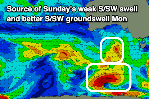 A new, small SW groundswell is due into the afternoon down South, but not above 2ft at Middleton, though stronger in power and noticeable.
Moving into Sunday and a small pulse of mid-period S/SW swell from a weak front passing under us today should maintain small 2ft waves across Middleton, with the Mid easing back to 1ft+.
Winds look great for both coasts, locally, light offshore (N/NW down South) ahead of afternoon S'ly sea breezes. The models are incorrectly combining swells into the afternoon so don't expect a jump as shown.
Now, our fun pulse of S/SW groundswell for Monday is on track, as is a new, secondary pulse of reinforcing SW energy.
The source of the S/SW swell will be a polar fetch of stalling W/SW gales on the polar shelf, tending more W'ly away from us while reaching severe-gale strength early tomorrow morning.
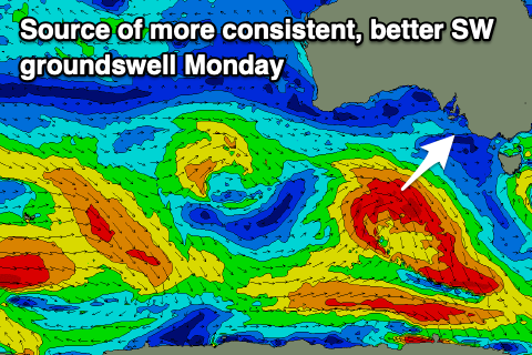 The secondary SW swell will be generated by a strong low forming south of Western Australia tomorrow, projecting a fetch of W/NW-W/SW gales through our swell window while dipping east-southeast.
Both swells are due on Monday, with a fun kick in size to 3ft due down South across Middleton, while the Mid is likely to see 1-1.5ft sets.
Winds will swing back around to the NE on Monday morning, likely N/NE at times down South and E/NE on the Mid before fresh E/SE sea breezes kick in from midday.
Similar but fresher winds are due on Tuesday as the mix of swells start easing back from 2-3ft across Middleton and 1ft on the Mid.
The surf will continue to ease through Wednesday and Thursday but a trough will bring an E/SE-SE change on the former, S/SE tending S/SW on Thursday. Both will be lay days.
Into Friday cleaner conditions should develop with offshore NW winds and a new mid-period SW swell may be seen. The models diverge on the strength and duration of the frontal system producing this swell but we should see a pulse of size hopefully at least to 3ft across Middleton, tiny on the Mid. More on this in Monday's update though. Have a great weekend!