Good surf for both regions tomorrow

South Australian Surf Forecast by Craig Brokensha (issued Wednesday September 21st)
Best Days: Later today Mid Coast, tomorrow and early Friday both coasts, Saturday Mid Coast, Sunday from later morning South Coast
Features of the Forecast (tl;dr)
- Moderate sized + W/SW swell for Thu, with a secondary stronger groundswell for Fri PM and Sat AM
- Light, local offshore winds tomorrow AM ahead of weak sea brezes
- Early W/NW tending strong S/SW winds mid-morning down South Fri AM, variable on the Mid ahead of the change mid-late AM
- Easing surf Sat PM with E'ly tending S/SE winds
- Smaller Sun with strong NE tending N winds
- Building mid-period W/SW swell Mon with strong W/SW winds
- Moderate sized W/SW groundswell for Mon PM and Tue AM with S/SW winds Tue
Recap
Windy but decent waves at the spots angled into the wind yesterday down South and to 2-3ft out Cliffs and Goolwa way, 1-1.5ft on the Mid Coast and fun on the right surf craft.
This morning we've got a shallow and shorter-lived S/SW change with 1-2ft sets on the Mid Coast and 2-3ft waves continuing across Middleton. We should see winds tending S/SE late across the Mid Coast so keep an eye on a little window into the evening.
This week and next (Sep 22 - 30)
From tomorrow through Saturday we'll see building levels of W/SW swell energy, both in size and power thanks to a strong, prolonged polar frontal progression that started last weekend around the Heard Island region. Back to back fronts have generated some good sized energy, with the largest pulse of W/SW groundswell due to fill in Friday afternoon and ease Saturday.
Tomorrow's first pulses of W/SW energy were generated on the weekend, and we should see inconsistent but good 3-4ft sets across Middleton tomorrow with 2ft sets on the Mid Coast.
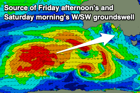 Similar sized waves are due into Friday morning ahead of the stronger W/SW groundswell pulse into the afternoon, kicking to 2ft+ on the Mid Coast, holding a similar size Saturday morning and 3-5ft across Middleton.
Looking at the local winds tomorrow, and today's trough will clear quickly to the east, leaving variable tending light N/NW winds on the South Coast, E'ly on the Mid Coast ahead of weak afternoon sea breezes. A good day of surf across both regions.
Come Friday the next approaching trough will bring early W/NW winds to the South Coast, before a strong S/SW change moves in mid-morning, variable on the Mid ahead of the change mid-late morning.
This trough will clear again to the east fairly quickly overnight, with winds due to swing back to the E/SE on the Mid Coast Saturday morning, E/NE-E down the South Coast.
Stronger NE winds are due early on Sunday, shifting more N'ly into the afternoon as another mid-latitude low approaches from the west along with easing levels of W/SW swell energy from 3ft across Middleton and 1-1.5ft on the Mid Coast.
Now, this mid-latitude low will bring some new mid-period W/SW swell energy with it on Monday but with strong W/SW winds. Sets to 2ft are due in the gulf, small and similar in size across Middleton.
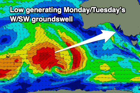 A better W/SW groundswell is due into the afternoon, peaking Tuesday morning, generated by a strong polar low firing up to the east of the Heard Island region over the coming days.
A good fetch of gale to near severe-gale W/SW winds will produce a moderate sized groundswell with it arriving Monday and building to 3-4ft through the afternoon, easing from a similar size on Tuesday.
The Mid looks to continue around 2ft Tuesday, easing through the day and winds should ease but still be S/SW, creating bumpy conditions across all locations. Wednesday looks cleaner with a S/SE breeze, but smaller, easing swell.
Longer term we've got smaller surf with NE winds into the end of the week, but more on this Friday.