Great surf for the South Coast, windows on the Mid

South Australian Surf Forecast by Craig Brokensha (issued Friday August 26th)
Best Days: Today South Coast, tomorrow South Coast, Sunday South Coast, Monday protected spots South Coast, Mid Coast Tuesday, South Coast Tuesday, South Coast Wednesday and Thursday
Features of the Forecast (tl;dr)
- Fun, reinforcing mid-period SW swell Sat AM, easing slowly with N/NE-NE tending variable winds, smaller Sun with mod-fresh N/NE tending N winds
- Moderate-large sized, long-period W/SW groundswell for Mon PM with strengthening W/NW winds ahead of a mid-late PM strong W/SW change
- Easing swell Tue with moderate SW winds (likely W/NW early around Victor and S/SE Mid Coast)
- Reinforcing mid-period SW swell Wed PM through Fri with light, local offshore winds each morning Wed and Thu
Recap
Winds didn't quite go light enough on the Mid yesterday morning with a lingering onshore wind and bumpy 1-2ft sets for the keen, bumpy also down South with plenty of size in that 4ft range across Middleton.
Today is much cleaner and better across the South Coast with an offshore wind and infrequent 3-4ft sets across Middleton, great on the Mid condition wise but back to a tiny 1-1.5ft. Winds should remain favourable most of the day with only weak sea breezes due, worth making the most of.
This weekend and next week (Aug 27 - Sep 2)
We've got a great weekend of surf due across the South Coast as a high moves in further from the west, clean tomorrow morning though straightest on Sunday.
The wind will have a N/NE-NE tendancy tomorrow morning along with a final pulse of reinforcing mid-period SW swell through the morning, easing into the afternoon and smaller Sunday. The source of this swell was a final fetch of strong to near-gale-force W/NW winds swinging in south-west of Western Australian the last couple of days and it should maintain 3ft sets across Middleton, then easing from 2ft+ on Sunday morning.
Winds into tomorrow afternoon look variable, lighter west of Victor and E/NE to the east. The Mid Coast will ease further in size leaving tiny waves for beginners.
Sunday will be offshore all day with a moderate to fresh N/NE tending N'ly breeze.
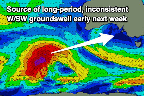 Moving into Monday and our strong, inconsistent W/SW groundswell is still on track, generated by a strong polar low that's currently tracking north-east towards Western Australia.
The low has generated a great fetch of severe-gale to storm-force W/SW winds in our far swell window and is holding its strength while tracking north-east into our western swell window. The low will weaken this evening and through tomorrow, with a moderate-large, long-period W/SW groundswell due to arrive Monday morning and peak into the afternoon.
Strong though inconsistent 4-6ft sets are due into late Monday afternoon across Middleton and other deepwater reefs, while the Mid Coast should build to 2-3ft late in the day.
Winds look best for the South Coast with a pre-frontal, fresh W/NW breeze on Monday morning, strengthening and then giving into a mid-late afternoon W/SW change just when the swell is expected to really muscle in.
The front will clear Tuesday but leave moderate SW winds in its wake, though if they ease off enough we'll likely see a morning W/NW breeze around Victor and possible S/SE winds on the Mid. We'll have one final more confident look at this on Monday. Either way with the light winds and quality swell there'll be good waves on offer across both coasts.
 The groundswell will still be solid but on the ease with dropping 2ft to occasionally 3ft sets on the Mid Coast and 4-5ft waves across Middleton.
Wednesday and Thursday looks much better down South with morning N/NW winds on the former and a further drop in size, variable Thursday.
Swell wise, we've got some fun reinforcing mid-period SW swell on the cards from Wednesday afternoon through Friday, generated by healthy polar frontal activity moving in from south-west of Western Australia during the weekend and early next week.
Size wise it looks to be 4ft on the sets across Middleton and only 1ft across the Mid Coast, but more on this Monday. Have a great weekend!