Coupla nice days in the midst of a windy wintry pattern

South Australian Surf Forecast by Ben Matson (issued Monday 25th July)
Features of the Forecast (tl;dr)
- Bumpy waves Tues, improving a little at Victor on Wednesday
- Light winds Thursday and a fun new swell for the arvo across both coasts
- Swell holding Fri with winds freshening NE
- Small weekend with freshening N'lies
- Building W'ly swells (and winds) early next week, with possibly more follow up fronts delivering similar patterns
Recap
Saturday was tiny at all coasts, but a new swell built on Sunday with 2-3ft sets at Middleton and even a few slow peelers on the Mid Coast in the 1.5ft range. Size eased right back again early this morning, though we are seeing some windswell building in the wake of a cold front that crossed the region mid morning.
This week (Jul 26 - 29)
Winds are currently westerly behind the front, and will veer more west south-west overnight before slowly easing through Tuesday. This will maintain below average conditions pretty much everywhere.
We’ve got some new swell on the way for tomorrow; some local windswell from the front but also some very inconsistent, distant W/SW groundswell, sourced from the early incarnation of the parent system a polar low in our far swell window. Size should reach 3-4ft at Middleton with 2ft waves on the Mid on the more favourable parts of the tide. Don’t get your hopes up.
Another front will stand up to the west on Wednesday, swinging the winds back around to the W/NW as wave heights ease across the region. It’ll remain small and wobbly on the Mid Coast however Victor should start to see a gradual improvement at some spots, though with abating size there won’t be a huge amount of options on offer. Expect 3ft sets at Middleton if you’re super keen.
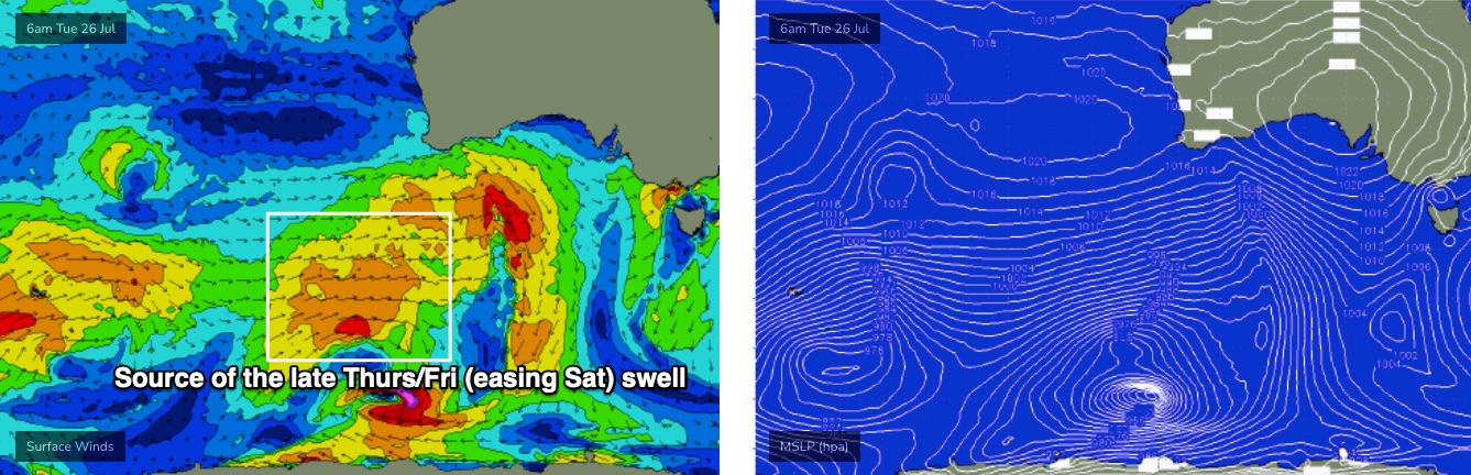
Thursday’s actually got some potential.
The frontal passage will have cleared to the east, and a building high pressure ridge will create light variable winds. Furthermore, a series of mid-range swells will fill into the coast, sourced from reasonable fronts tracking south of WA on Tuesday and Wednesday (see below). Although not super powerful, the alignment is pretty good within the Mid Coast's swell window, and we should see size building in the gulf to 2ft+ on Thursday afternoon (smaller early), holding into Friday as winds veer NE and freshen as a front approaches from the west.
Victor should build back up into the 3-4ft range at Middleton later Thursday (smaller earlier) but Friday looks to be the pick of the week down south with the freshening NE breeze (note: the wave models are calling 4-5ft Middleton Thurs/Fri, which I feel is a slight overcall, but let's see what happens).
Just bear in mind for Friday down south, that there is a risk we may see a smidge more E’ly in the flow early on, but I’ll have a better understanding of that in Wednesday’s update.
This weekend (July 30 - 31)
Looks like a weekend of two halves.
Friday’s swells will ease steadily into Saturday and freshening pre-frontal northerlies will favour the Victor stretch for good clean waves at the swell magnets. It’ll be small and bumpy on the Mid.
On Sunday, we’ll see even smaller waves at Victor (only suitable for the swell magnets), but there’s a chance for a new W’ly swell to show on the Mid through the day, sourced from westerly gales in the western Bight on Friday and Saturday. This is still a bit optimistic, as it’s likely that we’ll see strengthening N'lies around the same time (and, the W’ly swell is more likely to peak on Monday) but I’ll firm up the timings as the week progresses.
Long story short: aim for a surf sown south early Saturday before the swell dries up and the wind gets too strong.
Next week (Aug 1 onwards)
Strong frontal activity through the Bight looks like generating stacks of swell for the Mid Coast, but keeping wave heights only small at Victor due to the swell direction. Of course, this pattern will also result in a lot of strength in the local westerly wind, but the upshot remains active for the Gulf, and that’s not always a bad thing, even if wave quality ain’t high.
And, despite the storm track not aligning for Victor, we’ll see a few windows of good winds down south, which will favour small waves at exposed beaches.
More on this in Wednesday’s update.