Smaller swells with increasing winds

South Australian Surf Forecast by Craig Brokensha (issued Wednesday July 13th)
Best Days: Keen surfers South Coast magnets tomorrow morning, both coasts Friday, Saturday for the keen down South (tricky and windy), Sunday morning protected spots South Coast
Features of the Forecast (tl;dr)
- Easing mix of small to tiny swells tomorrow with light N/NW tending W/NW down South, E/NE tending N/NW on the Mid
- Late increase in W/SW swell tomorrow, peaking Fri with a S/SW swell in the mix
- N winds down South Friday, NE tending N on the Mid
- Easing surf Sat with strong N/NW winds
- Late pulse of SW swell Sat, peaking Sun AM with gusty W/NW tending W/SW-SW winds
- Easing surf early next week with light winds
Recap
Our new W/SW groundswell came in on forecast yesterday as well as the local offshore winds with clean 2-3ft sets on the Mid Coast and workable waves in protected spots down South to 2ft, bigger but bumpier further towards Goolwa. An onshore change moved through into the afternoon creating poor conditions across both coasts.
Today the winds are still onshore with 2-3ft surf across Middleton, clean on the Mid Coast early but back to a slower 1-2ft.

Good sets and light winds yesterday morning
This week and weekend (Jul 14 - 17)
Our current swell will continue to ease into tomorrow as winds ease and swing offshore down South. A light N/NW breeze should only tend W/NW into the afternoon but the surf will be fading from 1ft to possibly 2ft across Middleton, better on the magnets. The Mid should be clean enough with an early E/NE breeze but tiny 1ft+ leftovers.
Later in the day some new mid-period W/SW swell is expected on the Mid Coast, though peaking through Friday.
This and a small pulse of S/SW swell for the South Coast were generated by the same frontal system with it initially being a mid-latitude front, dipping south-east before generating a fetch of patchy, strong to gale-force W'ly winds on the polar shelf today/
The westerly component of the swell should produce inconsistent 1-2ft waves on the Mid Coast, with infrequent 2ft to possibly 3ft waves across Middleton. The South Coast models are over-forecasting the size a little so expect smaller surf than it's showing.
Winds will be best for the South Coast with a persistent N'ly offshore, NE on the Mid early but swinging more N'ly through the day but only moderate in strength.
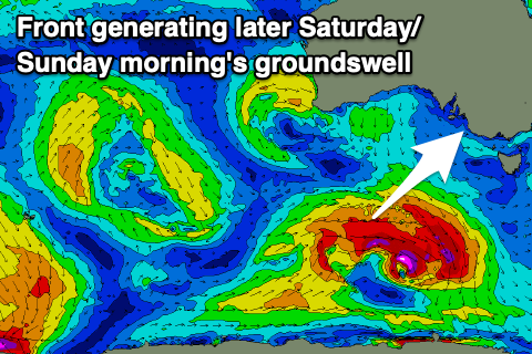 An approaching trough will bring stronger N/NW winds on Saturday with easing 2ft sets down South, tiny and choppy on the Mid Coast. A new pulse of mid-period SW swell is due later in the day across the South Coast, but Sunday morning is a better chance to see any new size. It's origins will be a relatively weak but favourably aimed fetch of strong to gale-force W/SW winds from a polar front tomorrow.
Fun 2-3ft sets should be seen across Middleton but winds will freshen from the W/NW ahead of a W/SW-SW change later morning.
Moving into next week a strong, slow moving high will result in smaller, background swell and favourable winds out of the northern quadrant most of the week. A fun final pulse of mid-period S/SW swell is expected Tuesday but we'll have a closer look on this Friday.