Classic autumn pattern to continue

South Australian Surf Forecast by Ben Matson (issued Friday 13th May)
Features of the Forecast (tl;dr)
- Building W'ly swells for the Mid over the weekend, though some wind at times (keep an eye out for an easing onshores late Sat)
- Small and clean down south over the weekend
- Large swells down south with some wind on Monday, plenty of (initially bumpy) surf on the Mid, improving later
- Very large surf down south Tues, easing Wed, light winds
- Plenty of fun surf Tues/Wed on the Mid with light winds
- Small spell developing from Thurs/Fri onwards under an E'ly wind regime
Recap
Small clean 1-2ft leftovers on the Mid on Thursday eased back to a slow 1-1.5ft this morning, and under 1ft this afternoon. Conditions have been clean with light winds. Victor’s seen equally clean conditions and easing surf from 3-4ft to 2-3ft at Middleton. A great close to an excellent autumn swell event.. hope you all got some.

Fun Middleton Bay this morning
This weekend (May 14 - 15)
No real changes to the weekend outlook..
A series of fronts will clip the coast, one on Saturday then another later Sunday, so we’ll be under a gusty wind regime swinging back and forth from the NW to W/SW.
There’s a whole stack of swell on the way too, though initially it’ll be very westerly in direction, originating from a powerful low spinning up immediately south of West Oz that’ll drive a strong front through the Bight.
It’s lagging a little behind model runs from early in the week, so expect Saturday to start off undersized with freshening NW winds, ahead of a strong increase through the afternoon, reaching 3-4ft late in the day at reliable reefs.
Ironically, despite the passage of the front to our south through the middle of the day, it’s possible that we’ll see a temporary slackening of the pressure gradient in its wake (across the gulf) that may lead to light winds developing mid-late afternoon. It’s not a certainty but is well worth keeping an eye out for - peg your expectations under 'bumpy' but don't be surprised if it ends up 'lumpy'.
Down south, today’s surf will bottom right out and the initial swell increase on Saturday arvo will be too west to favour any major size here. So, hit up the regional swell magnets for small clean waves around 2ft.
Sunday will see freshening NW winds as the next front approaches, and therefore bumpy conditions on the Mid, and clean but blustery conditions down south. Surf size on the Mid will ebb and flow as a series of westerly groundswell overlap; early morning may ease back to 2-3ft but I’m expecting an afternoon push back up into the 3-4ft range - though it’ll be bumpy under the onshore breeze.
Down south, surf size will pick up a little but it wave heights will still be heavily diluted thanks to the dominance of the W’ly swell direction (so, maybe some 2-3ft sets at Middleton through the morning).
However a secondary SW swell will start to show later and we can’t run out some bigger sets showing into the afternoon - but confidence isn’t high. Conditions should be good here though the wind will become quite strong at times.
Next week (May 16 onwards)
The models have swung back and forth regarding the upcoming storm track all week (relative to its proximity to the SA coast), and therefore the impact it’ll have on local surf conditions. However we’re now much closer to the event so confidence is becoming stronger on what we’ll see.
And that is…. Plenty of wind on Monday with building swells, then a period of light winds, coinciding with a LOT of swell.
The parent low to the weekend’s fronts is a complex beast, already beginning to undergo cyclonegensis in a few regions, as a polar low (off Antarctica, south of WA) and a cut-off low in the western Bight (as mentioned above).
These lows will coalesce to form a large primary system by Sunday - generating a mix of mid-range swells from the W/SW thru’ SW quadrant, and surf size will build correspondingly through Monday, initially 4-5ft at Middleton but likely to be a couple of feet bigger by the afternoon.
Early morning will maintain fresh westerlies though this will be on the backside of the frontal passage and so will ease throughout the day. We should see a brief period of W/NW winds throughout Victor, and probably less strength in the gulf where surf size should maintain bumpy but improving 3ft+ sets throughout the day.
Tuesday will see a peak in size, originating from a powerful front wrapping around the northern flank of the primary low, late Sunday into Monday (see below). Direction will slowly turn from the W/SW to the SW through the day, and it’s like that we’ll see a peak in size through the afternoon.
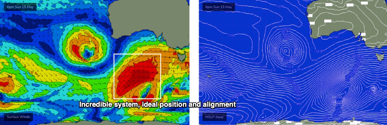
I really don’t want to over-egg the omelette, but the associated fetch is lining up in the best part of Victor’s swell window (relative to surf size and consistency), and will remain slow moving as it reaches maturity, drawn out over an impressive 30-odd hours or so, which helps to exaggerate eventual surf size above the usual model expectations. It's not a common event.
What this means is that we’re looking at a very large, powerful surf down south on Tuesday. How big? In Wednesday’s forecast I mentioned a general size range of 6-8ft+ surf, with a chance for bigger sets at the swell magnets - and if anything I feel a little more confident that we could see occasional 10ft+ sets at some of the offshore reefs that efficiently focus long period swells.
Even better, a weak ridge of high pressure is expected to push into the region, delivering light variable winds. Ideally we’d have an offshore to iron out the weekend wobbles, and this isn’t likely, but it’s shaping up to be a very big, clean(ish) day of waves.
On the Mid Coast, this fetch won’t line up perfectly but it’s still big enough to overcome some of the directional deficiencies. Let’s peg wave heights around the 3ft mark, but lower the confidence levels to allow for all of those unusual variables the Mid throws our way once the direction tends more south of west.
Easing size is then expected Wednesday, from an early solid peak, still perhaps 6-8ft down south, and maybe 2-3ft on the Mid, with light winds and clean conditions. You’ve gotta book in some water time through this period.
Looking further ahead, and we’ve got an easterly flow developing from Thursday thru’ Sunday as a high pressure system sets up south of the state and a surface trough develops over Western Australia.
We’ll see easing size from Thursday onwards, in fact we’re now looking at a spell of small waves thanks to a blocking pattern upstream diverting Southern Ocean fronts away from our swell window.
Have a great weekend, see you Monday!
Comments
Omg fucking exciting... cyclonegenesis
Tasty ASCAT pass overnight.