Fun weekend down South, slowing on the Mid

South Australian Surf Forecast by Craig Brokensha (issued Friday May 6th)
Best Days: Today Mid Coast, keen surfers Mid Coast tomorrow, South Coast tomorrow (protected spots PM) and Sunday, South Coast Monday morning, Mid Coast Wednesday and Thursday for the keen, South Coast Thursday
Features of the Forecast (tl;dr)
- Easing swells tomorrow with a weak S'ly swell in the mix. Early E/NE-NE tending W winds on the Mid, NW tending W/NW-W/SW winds down South
- Fun, mid-period S/SW swell Sun with variable offshore tending weak E/SE winds
- Easing swell Mon with N/NE tending E/SE winds
- Low point in swell Tue with N/NE tending E/SE winds
- Inconsistent mix of W/SW swells filling in Wed, easing slowly Thu
- E/NE tending E/SE winds Wed, NE Thu
Recap
Great surf across the Mid Coast yesterday with a peak in large W/SW swells and winds played out as expected early morning, but remained favourable all day with the troughy, cold weather across the state. Consistent 3ft surf was seen with the rare bigger one across the magnets. The South Coast was sizey but poor with strong onshore winds, but these also tended variable through the day creating improving conditions.
Today the surf is still really fun on the Mid Coast with clean 2ft+ waves, onshore and bumpy down South. Like yesterday winds have eased temporarily and shifted more west but they'll likely not last.

Solid and clean yesterday
This weekend and next week (May 7 - 13)
The current swell will continue to ease into the weekend with the Mid Coast becoming tiny in size tomorrow, but surfable on the right equipment. 1-1.5ft sets are expected, while the South Coast should see easing sets from 3ft across Middleton. There’ll be some small, weak S’ly swell in the mix but under the size of the existing SW energy.
 Conditions will be much cleaner down South as winds swing offshore, blowing from the NW, shifting W/NW-W/SW through the day. The Mid Coast will be best early with an E/NE-NE breeze, shifting onshore later morning.
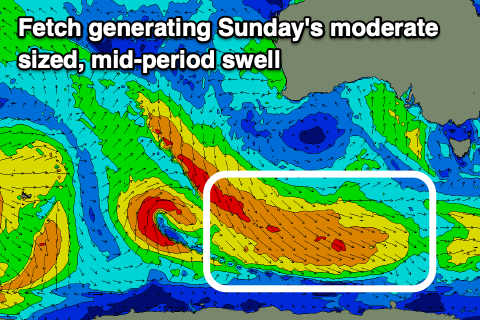
Our new mid-period S/SW swell for Sunday is on track generated by a broad, healthy fetch of strong to gale-force NW tending W/NW winds swinging in along the polar shelf the last two days. This was not ideally angled in our swell window but we should still see a fun reinforcing swell to 3ft across Middleton, easing from 2-3ft on Monday morning. The Mid Coast will be tiny.
Winds on Sunday will be favourable again, variable tending light offshore with weak E/SE sea breezes.
Monday will be great with a N/NE offshore ahead of weak E/SE sea breezes again, but get in through the morning before the swell fades.
A low point in swell is expected Tuesday with N/NE tending E/SE winds again, with some new, inconsistent W/SW swell due to fill in Wednesday.
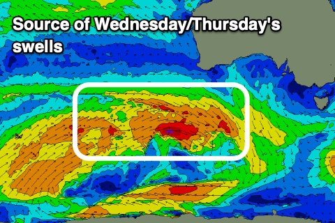 There looks to be a mix of swells in the mix, generated by a distant frontal progression, south-west of Western Australia, with this dipping on approach to us while strengthening. We may see some additional SW energy from the latter stages, but we’ll review this on Monday.
Regardless the Mid Coast should see inconsistent 1-1.5ft surf developing Wednesday with Middleton building to an inconsistent 3ft or so. An inland low across NSW looks to bring funky E/NE tending E/SE winds on Wednesday, favouring the Mid, with Thursday being better down South with NE tending variable winds as the swell eases from a similar size. Check back Monday for confirmation.
Longer term we’ve got a very tricky outlook with a mix of polar fronts and mid-latitude troughs moving in from the west bringing some volatile weather. More on this Monday. Have a great weekend!