Strong swell due tomorrow with light morning winds

South Australian Surf Forecast by Craig Brokensha (issued Wednesday April 20th)
Best Days: This morning down South, tomorrow morning South Coast, all day Mid Coast, Mid Coast Friday for the keen and beginners, South Coast Sunday morning, South Coast Monday morning and Tuesday morning
Features of the Forecast (tl;dr)
- Mid-period W/SW swell tomorrow with a larger, building S/SW groundswell
- Light, morning N winds down South, tending fresh S/SE into the PM (E/SE tending S/SW then SE late on the Mid)
- Easing mix of swells Fri with mod-fresh E/SE tending S/SE winds, smaller Sat with moderate E-E/SE tending fresh S/SE winds
- Inconsistent SW groundswell building Sun PM with E/NE-NE tending SE winds
- Easing, inconsistent SW groundswell Mon with NE tending SE winds, similar Tue with small, fading surf
- New W swell for Fri, with larger surf likely next weekend
Recap
A fun kick in new W/SW swell on the Mid Coast to 1-2ft yesterday, bumpy but workable early and then average and choppy into the afternoon. Today the swell is holding 1-2ft but with fresh onshore winds.
The South Coast was choppy and poor yesterday with plenty of size, cleaner this morning in protected spots with 3ft sets. Another SW change is due to move in later morning, though not too strong, shifting S/SW later.

Fun surf this morning
This week and next (Apr 21 - 29)
Looking at the coming days of surf and we've got a large mix of long-period S/SW groundswell and mid-period energy due to arrive through tomorrow, peaking during the day and with more favourable winds in the morning.
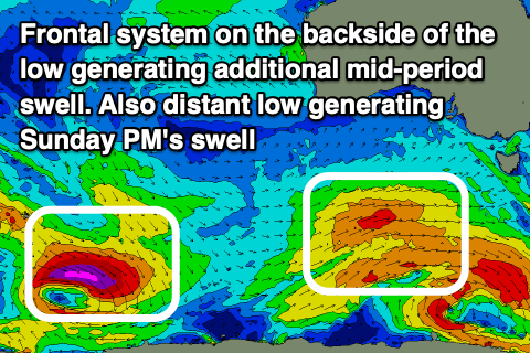 The source of these swells was a strong polar low generating a fetch of severe-gale to storm-force winds Monday and Tuesday, with a front spawning off the low bringing the mid-period energy.
We should see Middleton building to 5-6ft through the middle of the day/afternoon with the Mid Coast holding 1.5ft with the chance of 2ft sets continuing across the magnets thanks to a reinforcing, mid-period W/SW swell.
Winds look great and light from the N'th on the South Coast, E/SE on the Mid with a S/SE sea breeze down South and S/SW winds on the Mid, shifting back SE later.
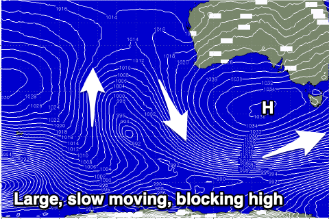
Friday will be poor as a strong high starts muscling in from the west, bringing moderate to fresh E/SE morning winds down South with easing 4-5ft sets off Middleton with 1-1.5ft sets on the Mid Coast.
Winds should ease a touch Saturday as the high pushes slowly east, but from an E/SE-E direction creating less than ideal conditions across the South Coast as the surf eases further. Sunday looks better with an E/NE-NE offshore wind and new, inconsistent building SW groundswell.
 The source of this swell will be a strong though distant low firing up south-east of the Heard Island region last night. A strong fetch of severe-gale to storm-force W/NW winds are being generated before the low pushes down into the polar shelf. The swell will be inconsistent but sets to 3ft are due into the afternoon across Middleton, smaller 2ft in the morning. The Mid won't see any size from this source.
Easing 3ft sets are due Monday morning with a morning NE breeze, with fading surf into the middle of the week as the blocking effects of the strong high start to be felt locally. Winds will hold from the NE Tuesday, more N/NE on Wednesday and N/NW Thursday ahead of a surface trough moving in from the west.
This trough looks to generate some new W/SW swell for Friday ahead of a stronger swell producer for next weekend as mid-latitude storms fire up to our west. More on this Friday.
Comments
"Winds look great and light from the N'th on the South Coast"
Can't see that on any models, talking from experience?
Hi-res modelling has variable N-NE..
With that I'd just expect variable winds, tending NE during the morning ahead of afternoon SE winds.
This is 7am.

Oh ok seems like ACCESS C has a great resolution but not making the most of it . Can forecast a morning land breeze elsewhere. Granted though the nly may not be land breeze strictly speaking
Looking solid and pretty clean..
Score Mitch? Swell looked solid with waves all over. One reef looked 6-8ft and the Mid is a fun as 2ft. Everywhere pumping.
Nope. Not for lack of solid swell and light winds though. More a lack of balls to paddle out to reefs I've never seen before and no one is surfing. I'm on ki
Haven't been on a surf trip since COVID began so just getting out the back and looking into 4ft closeout beachies has been a thrill of its own
Oh sick would have been very solid out that way! Enjoy.
Cheers
I imagine being a local here or around Middleton is frustrating. Unless you wanna go on a mission to get a wave it's either too big or too small
http://www.bom.gov.au/products/IDS65031.shtml
Big swell yesterday, looks like a fun Sunday and Monday! OweDanny Boy