Less than ideal winds with plenty of swell

South Australian Surf Forecast by Craig Brokensha (issued Monday April 18th)
Best Days: Wednesday morning South Coast,, Thursday morning both coasts (for the keen on the Mid), Sunday morning South Coast for the keen
Features of the Forecast (tl;dr)
- Inconsistent SW groundswell building Mon PM, easing Tue with moderate S tending SW winds (S/SE on the Mid in the AM)
- Small to tiny W/SW swell Tue, better Wed
- Moderate W/NW winds early Wed, tending SW mid-late AM
- Mid-period W/SW swell Thu with a larger, building S/SW groundswell with light E/NE tending S winds
- Easing mix of swells Fri with moderate E/SE tending S/SE winds, smaller Sat with similar winds
- Inconsistent SW groundswell building Sun with E tending S/SE winds
Recap
Great conditions continued across the South Coast on the weekend with a temporary low point in swell Saturday morning though still 2-3ft, with a new S/SW groundswell building into the afternoon, providing 3-4ft sets yesterday morning.
Conditions were best early yesterday ahead of an approaching trough and SW change. The shallow nature of the change saw winds become variable into the late afternoon and evening, only light to moderate this morning but with lumpy 2-3ft leftovers.
This week and weekend (Apr 19 - 24)
Into this afternoon a new SW groundswell should fill in, generated by a strong though slightly fractured polar low, south west of Western Australia late last week. Sets to 3-4ft are due across Middleton, easing from a similar size tomorrow morning. The Mid will be tiny this afternoon but a new, weak W/SW swell is due tomorrow to 1ft to possibly 1.5ft, generated by a weak frontal system moving in from the Indian Ocean on the weekend.
Winds will remain average and moderate out of the S'th tomorrow (S/SE on the Mid) with afternoon SW winds due to develop across both coasts as a cold front approaches.
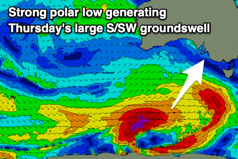
This front will be ahead of a strong polar low moving through our swell window, generating a large S/SW groundswell for Thursday, but coming back to Wednesday and the front will tip winds temporarily to the W/NW ahead of a SW change mid-late morning. Size wise Middleton looks to be around 2-3ft, with some new mid-period swell for the afternoon.
 The Mid Coast should offer 1.5ft waves through Wednesday but with that onshore breeze.
Looking at Thursday's large S/SW groundswell and this will be generated by the low proper with a fetch of severe-gale to storm-force W/SW winds forecast to be produced through our swell window today and tomorrow.
The swell should arrive Thursday and peak through the middle of the day/afternoon with sets to 5-6ft across Middleton. The Mid Coast should see 1.5ft surf with the chance for the rare bigger one on the favourable parts of the tide. Winds should improve temporarily as a high moves in behind Wednesday's change with light E/NE winds during the morning across the South Coast, E/SE on the Mid ahead of sea breezes.
 Unfortunately the high will remain slow moving into Friday and the weekend, leaving persistent E/SE winds across our region in the mornings, creating bumpy waves down South as the S/SW swell energy slowly eases.
Winds should start to improve and swing more E/NE-NE next week as the high pushes further south. Swell wise, the high will block our western swell windows, though we'll see some good S/SW groundswell emanating from strong polar frontal activity. More on this Wednesday.