Fun weekend, tricky winds next week

South Australian Surf Forecast by Craig Brokensha (issued Friday April 15th)
Best Days: South Coast tomorrow morning, dawn Sunday but good in protected spots until midday, Mid Coast for the keen Tuesday, South Coast Wednesday morning, Mid Coast Thursday
Features of the Forecast (tl;dr)
- Low point in swell tomorrow AM with light N/NE-E tending E/SE winds
- Building S/SW groundswell Sat PM, easing Sun with mod-fresh N/NW winds, shifting W/NW and then SW by midday
- Inconsistent SW groundswell building Mon PM with freshening S/SE winds, easing Tue with stronger S/SE winds
- Small W/SW swell Tue and Wed
- Mid-period SW swell building Wed with fresh W/NW tending SW winds
- Large S/SW groundswell Thu with mod-fresh S/SE winds
Recap
Great conditions across the South Coast the last two days with 2-3ft sets across Middleton yesterday morning, a bit stronger and more 3ft this morning with a reinforcing groundswell. The Mid was tiny to flat yesterday with a tiny hint of swell today. Winds will shift S'ly through the day but without much strength.
This weekend and next week (Apr 16 - 22)
We're looking at a really fun weekend of surf for the South Coast, best early Sunday with the most size and offshore winds.
 Into tomorrow morning we'll fall in between swells but Middleton shouldn't drop below 2ft to occasionally 3ft with the Mid Coast remaining tiny.
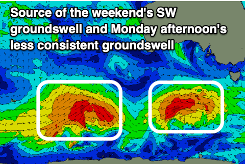
Into the mid-late afternoon we should see our new pulse of S/SW groundswell filling in, generated by a healthy polar front that's been moving through our swell window since yesterday and is generating strong to gale-force W/SW winds in our southern swell window today.
Middleton should kick to a strong 4ft but a morning N/NE-NE offshore will give into E/SE-SE sea breezes, creating bumpy conditions.
Sunday looks the pick with easing surf from 3-4ft across Middleton and an early N/NW breeze, but this will quickly shift W/NW by mid-late morning ahead of a SW change midday. So go the early.
Behind this change a high will move in, bringing moderate S/SE winds on Monday that will freshen during the day, creating deteriorating conditions. The Mid Coast will be clean though tiny and some inconsistent SW groundswell should build into the afternoon down South.
This will be generated by a more fractured polar low that's currently east of the Heard Island region. A distant fetch of strong to gale-force winds are being generated and the size of this swell will be inconsistent and peaking Monday afternoon to 3-4ft across Middleton.
 Tuesday will see easing surf from a similar size but with stronger S/SE winds ahead of a cold front which will swing winds temporarily W/NW into Wednesday morning and then SW into the afternoon.
This cold front will be attached to a great polar frontal progression firing up through south-west of Western Australia on Sunday, strengthening while pushing under the country next week.
This will be a sustained and multi-threaded frontal progression with some new, mid-period SW energy due to build later Wednesday ahead of a larger S/SW groundswell on Thursday, peaking into the afternoon.
Unfortunately behind Wednesday's front we'll see another high move in bringing S/SE breezes, creating poor conditions at the peak of the swell Thursday. Middleton should come in at 6ft with 1-1.5ft waves on the Mid and the odd possible 2ft set. There should also be a tiny 1ft to possibly 1.5ft of swell Tuesday and Wednesday ahead of the swell. More on this Monday though. Have a great weekend!
Comments
WAMS look good again