Good swell with favourable winds incoming

South Australian Surf Forecast by Craig Brokensha (issued Monday March 14th)
Best Days: South Coast tomorrow morning and Wednesday morning, Mid Coast Friday and Saturday, for the keen and beginners Sunday, South Coast Saturday morning and Sunday through Tuesday mornings
Features of the Forecast (tl;dr)
- Reinforcing mid-period S/SW swell tomorrow with NE tending E/SE winds, easing Wed with fresher N/NE winds and sea breezes
- Moderate sized + W/SW groundswell building Fri with strengthening S/SE winds, easing Sat with E/NE tending S/SE winds
- Reinforcing W/SW groundswell Sun with variable winds, easing Mon with variable tending S/SE winds
Recap
Improving conditions down South through the weekend with a light offshore developing through Saturday morning along with a drop in swell from Friday to a peaky 2ft. Yesterday was the pick and the best it's been in a while with clean conditions and a new S/SW groundswell to 3-4ft. The Mid Coast was tiny all weekend.
Today the swell has dropped back to 2ft but conditions are again great with a light E/NE breeze, flat on the Mid.
This week and weekend (Mar 15 - 20)
Winds will continue to be great for the South Coast over the coming days but the swell on the smaller side, fading into Wednesday and bottoming out Thursday.
Therefore make the most of tomorrow when a small, new, mid-period S/SW swell fills in, generated by a weak fetch of W/SW winds trailing the strong polar low linked to yesterday's groundswell.
2-3ft sets should be seen across the Middleton stretch with tiny surf persisting on the Mid Coast and with a NE offshore and E/SE sea breezes. Wednesday will ease from a slow 2ft on the sets with fresher N/NE winds ahead of sea breezes.
Come Thursday conditions should be clean again early with a light NE offshore but a trough will bring a SW change late morning, strengthening from the S/SW into the afternoon and then shifting S/SE on Friday as high moves in from the west.
 More importantly we've got our good W/SW groundswell due into Friday afternoon, easing back Saturday with a reinforcing pulse for Sunday.
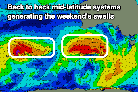
These swells will be generated by a healthy progression of mid-latitude frontal systems, strengthening while projecting up and under Western Australia from tomorrow.
The first system will be strongest and generate a great fetch of W/SW gales through our western swell window before dipping south-east on approach Thursday.
This will generate a moderate sized + W/SW groundswell that should build from 1-2ft Friday morning to 2-3ft into the afternoon on the Mid Coast, then ease from 2-3ft on Saturday. The South Coast should build to 4ft later Friday with easing sets from the 4ft range Saturday morning along with an E/NE breeze. This will open up plenty of locations, with Sunday coming in at 3ft to occasionally 4ft as a reinforcing W/SW groundswell fills in. The Mid looks to be a slow 1ft to maybe 2ft.
The source of this swell will be a secondary mid-latitude front firing up on the back of the initial system and winds look tricky but variable with a trough moving in from the west. Monday and Tuesday look clean for the South Coast with NE winds as the swell fades and becomes tiny on the Mid Coast. More on this in Wednesday's update though.