Poor run for the South Coast, small to tiny on the Mid

South Australian Surf Forecast by Craig Brokensha (issued Friday March 4th)
Best Days: Possibly protected spots this afternoon South Coast, Mid Coast late tomorrow, Mid Coast for the keen Wednesday, South Coast Thursday and Friday mornings
Features of the Forecast (tl;dr)
- Small, mid-period W/SW swell Sat with fresh S/SW winds (tending S/SE on dark), easing Sun with strong S/SE winds
- Mix of new SW groundswell and S/SE windswell Sun with strong S/SE winds, easing Mon with moderate S/SE winds, strengthening into the PM
- Moderate sized SW groundswell for Wed with fresh SE tending strong S/SE winds, easing a touch Thu with morning E/NE winds, smaller Fri with a light E/NE breeze
Recap
Really fun surf down South yesterday morning with clean conditions and fun 2ft sets across Middleton, bigger on the magnets. Today a strong SW change moved through just on dawn, creating average conditions but it's since eased and tended back to the W/SW, but with the small swell it's nothing great. The Mid Coast has been flat and unsurfable.
Winds are due to shift back to the W/NW this afternoon ahead of a trough/low so keep an eye on the local observations and cameras.
This weekend and next week (Mar 5 - 11)
These notes will be brief due to communication issues with our other forecasters in northern NSW.
The trough/weakening low linked to today's strengthening W/NW winds will move through this evening, leaving gusty S/SW winds across both coasts into tomorrow morning along with a new, mid-period W/SW swell.
This swell should provide surf mostly to 1.5ft but with 2ft sets on the Mid Coast magnets but winds will create bumpy/choppy conditions. Winds should shift S/SE on dark tomorrow so keep an eye on that window.
 Into Sunday poor, strong S/SE winds will clean up the Mid Coast but with a tiny, bumpy 1-1.5ft wave, choppy and a mess down South. There'll be a new SW groundswell in the mix Sunday down South but the winds will make it a write-off.
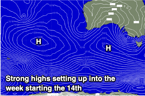
Unfortunately conditions will remain poor into early-mid next week with a new ridge of high pressure pushing in from the west, with a moderate S/SE tending strong S'ly breeze due Monday, strong from the S/SE on Tuesday.
It looks like winds will shift SE on Wednesday morning but remain fresh with Thursday and Friday mornings seeing more favourable E/NE winds.
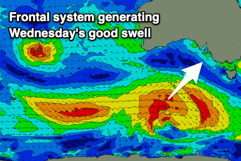
Swell wise a fun new mid-period SW swell is due on Wednesday, generated by a healthy polar frontal system moving in from a position east of the Heard Island region tomorrow, under the country early next week.
 Surf to a good 4ft+ is due across Middleton with the Mid Coast coming in at 1-1.5ft, the best of the bunch with the SE winds.
The swell will ease slowly through Thursday with those more favourable E/NE breezes, dropping from 3ft+ across Middleton and 3ft on Friday with a reinforcing mid-period SW swell.
Longer term high pressure looks to dominate our main swell windows resulting in persistent easterly winds and no major surf. More on this Monday, have a great weekend!
Comments
need those highs to piss off out of the bight and make their way towards alice springs.