Large westerly swell inbound

South Australian Surf Forecast by Craig Brokensha (issued Monday February 7th)
Best Days: Wednesday on the Mid Coast, Thursday on the Mid Coast, Friday on the Mid Coast for beginners, South Coast Saturday morning and Sunday morning
Features of the Forecast (tl;dr)
- Fading surf tomorrow with gusty N/NE tending N/NW winds
- Large W'ly groundswell building Wed with moderate W/SW-SW tending fresher S/SW winds late
- Easing W/SW groundswell Thu with S/SE tending S/SW winds
- Easing S/SW swell Fri with mod-fresh E/SE tending S/SE winds
- Inconsistent SW groundswell building Sat PM, peaking Sun with N/NE tending S/SE winds
Recap
Average waves to kick off the weekend with an E/SE-E breeze and weak swell, much better yesterday morning across selected breaks with a NE offshore and peaky 2ft of S/SE windswell.
Today winds are out of the NE again but with a smaller, weaker fading 1-2ft of S/SE swell.
The Mid has been clean but tiny to flat.
This week and weekend (Feb 8 - 13)
The surf will continue to drop in size and power tomorrow, becoming tiny under a gusty N/NE tending N/NW breeze as a strong but weakening mid-latitude low pushes in from the west.
 The low will bring a shallow W/SW-SW change on Wednesday, with winds shifting S/SW later in the day and back to the S/SE on Thursday morning as the low tracks south-east.
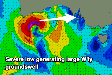
This low is now deepening below Western Australia’s South Coast, with a great fetch of gale to severe-gale W/SW winds due to be generated through the Mid Coast’s swell window. The low will weaken while projecting east tomorrow, dropping south-east out of our swell window into Wednesday.
A large W'ly groundswell is due Wednesday, building rapidly through the day and reaching 3ft to occassionally 4ft (on the magnets) into the afternoon on the Mid Coast. It’ll be bumpy but well worth a surf.
The South Coast won’t see much in the way of swell due to the blocking effects of Kangaroo Island, possibly reaching 2-3ft towards Goolwa on dark but onshore, then coming in at 2-3ft on Thursday with those S’ly winds. The Mid Coast will be best with the morning S/SE breeze and easing 2-3ft waves. The afternoon will become bumpy before cleaning up later again.
Winds are due to shift E/SE on Friday as the swell fades, back from 1-1.5ft on the Mid Coast (if that) and 2-3ft down South from the backside of the low continuing to provide S/SW swell energy.
Winds are expected to swing offshore into Saturday morning down South from the NE with small 2ft leftovers, but into the afternoon an inconsistent SW groundswell is due, peaking Sunday morning. This will be very inconsistent, originating from the southern Indian Ocean but Middleton should offer 2-3ft sets, tiny on the Mid Coast. Conditions will be clean again Sunday morning with a N/NE offshore ahead of a trough and S/SW change.
Longer term the increased Southern Ocean activity mentioned last update looks to have gone off the boil unfortunately which is a shame as both the leading global forecast models had some kind of development. Check back Wednesday for further updates.