Poor outlook with unfavourable winds

South Australian Surf Forecast by Craig Brokensha (issued Wednesday November 10th)
Best Days: Protected spots Monday, Tuesday morning next week South Coast, and likely Wednesday morning South Coast
Features of the Forecast (tl;dr)
- Average mix of swells tomorrow with strong E/SE tending S/SE winds
- Small mix of swells Fri with strong S tending S/SW winds
- Small mix of swells Sat with fresh S/SW tending SW winds
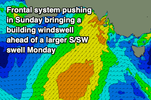
- Building SW windswell Sun with early, strong W tending SW winds
- Large, mid-period S/SW swell Mon with fresh W/SW tending SW winds (likely W'ly early in Victor)
- Easing S/SW swell Tue with variable morning winds and afternoon sea breezes
Recap
A good pulse of new SW swell filled in across the coast yesterday but the huge morning tide on the Mid swallowed up the 2ft sets, while becoming bumpy and choppy into the afternoon on the low tide. The South Coast was great with clean conditions and 3ft surf across Middleton, bumpy but fun into the afternoon with increasing S'ly winds.
Today the surf is poor with a stronger S/SE breeze in the wake of a trough yesterday afternoon and choppy 2-3ft waves down South, cleaner on the Mid but back to a full 1ft.
This week and next (Nov 11 - 19)
As touched on in Monday's notes, yesterday was the day to surf with poor swells and conditions due from today, extending until mid next week.
 The reason for this run of poor surf and winds is a large, blocking high sitting south-west of us and Western Australia, remaining near stationary as cold fronts push up and into Victoria, directing persistent winds out of the southern quadrant across the state.
We'll see winds tend more E/SE tomorrow morning but strong in nature, creating choppy, poor conditions down South with a mix of swells to 2-3ft, easing through Friday as winds revert back to the S'th and remain strong, tending S/SW later. The Mid Coast will be cleaner tomorrow but tiny to flat and then wind affected on Friday.
Into Saturday winds will shift slowly more SW through the afternoon from a morning S/SW'ly as a strengthening polar front projects up from the south, but swell wise there's nothing major due with a mix of windswell and small mid-period swell to 2ft across Middleton.
Sunday will likely see early, strong W'ly winds, shifting more SW through the day as the front pushes up and into Victoria, clipping us, but again there'll be no decent swell in the water early. As winds shift south-west the swell should start to build, likely reaching 3-5ft by late, ahead of a larger, mid-period S/SW swell on Monday. The Mid Coast looks to build to a choppy 2-3ft into the afternoon.
 The source of the large swell will be broad but not overly strong S/SW winds projecting up through our southern swell window on Saturday and Sunday, with Middleton due to come in around the 6ft range Monday with gusty W/SW tending SW winds. There's an outside chance for an early W'ly in Victor Harbor, while the Mid Coast will be bumpy and coming in at 2ft+.
As the frontal progression slowly clears to the east Tuesday, winds should relax and tend variable, creating cleaner conditions across both regions, easing back from 1-1.5ft on the Mid Coast and 4-5ft across Middleton. Wednesday may see winds out of the east with a further drop in swell ahead of a trough and return to onshore S'ly winds later week but we'll have a closer look at this on Friday.