Improving outlook from late week

South Australian Forecast by Craig Brokensha (issued Monday 20th January)
Best Days: Desperate surfers South Coast tomorrow mid-late morning, Thursday morning South Coast, Friday and Saturday mornings both coasts, Sunday morning South Coast
Recap
Better conditions for keen surfers across the South Coast Saturday morning with a peaky mix of swells to 2-3ft, poor yesterday with no real decent size. The Mid Coast was tiny to flat all weekend.
Today both regions were poor again with a tiny and choppy swell on the Mid Coast, poor and junky down South with a kick in S'ly windswell but with strong S'ly winds.
This week and weekend (Jan 21 – 26)
Winds are due to back off overnight and tend variable on the South Coast tomorrow morning, along with a small and easing S'ly windswell mixed in with a background mid-period SW swell.
Size wise, Middleton will be 2ft max, best on the swell magnets and likely mid-late morning with that variable E'ly wind ahead of S/SE sea breezes. The Mid Coast will be tiny to flat.
 A moderate to fresh N/NE wind will create excellent conditions Wednesday morning, shifting W/NW late morning ahead of a SW change, but there'll be no size left at all on the South Coast.
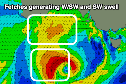
The end of the week is a little more promising, with a mid-latitude front come mid-latitude low forecast to move in from the west over the coming days.
An initial fetch of strong W/SW winds will be aimed through our western swell window, with a much tighter core fetch of W/SW gales generated more in our south-western swell window as the low stalls south of the Bight.
We'll then see this core fetch projected east-northeast through our south-western swell window, with yet another weak front trailing it.
What this all adds up to is a good pulse of W/SW swell for Thursday, with some better aligned SW swell for the South Coast on Friday, easing slowly Saturday.
The Mid Coast should see semi-stormy 2-3ft waves on Thursday but with strong W/NW tending W/SW winds, small and clean on the South Coast early and to 2ft or so, building to 3ft later in the day but with the change.
 Friday looks to ease from 2-3ft on the Mid Coast, with 3-4ft waves off Middleton and winds should back off in strength, moderate W/NW in the morning and W/SW into the afternoon.
Saturday looks great down South with a morning NW breeze and easing sets from 3ft to occasionally 4ft off Middleton, 2ft on the Mid Coast ahead of sea breezes. Sunday is expected to be clean again with a morning W/NW breeze but a touch smaller.
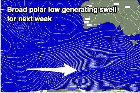
Next week onwards (Jan 27 onwards)
Moving into next week and we've got plenty more SW swell on the cards, with a broad stalling polar low due to develop south of Western Australia on Friday, with multiple embedded fronts spinning around it, creating various fetches of strong to gale-force W/SW winds through our south-western swell window.
A final push towards us is then expected early-mid next week, with the end result being a prolonged moderate sized SW swell event from Monday through most of next week and with generally light morning winds. More on this in Wednesday's update though.