XL W/SW swell for Sunday with strong westerly winds

South Australian Forecast by Craig Brokensha (issued Friday 4th August)
Best Days: Stormy options Mid Coast Sunday, South Coast tomorrow and protected spots Sunday morning, South Coast Tuesday and Wednesday
Recap
Funky winds and weather yesterday with a light morning E'ly across the South Coast and surf in the 3ft range, while the Mid Coast was super clean with 1-1.5ft sets.
Today a reinforcing SW swell has kept the South Coast ticking in the good 3ft range off Middleton with perfect conditions, while the Mid is deteriorating with a strengthening northerly wind and choppy 1-1.5ft of swell.
A W'ly change is due through this afternoon as in the lead up to this we'll see windswell building on the Mid Coast, further late in the day.
This weekend and next week (Aug 5 - 11)
Currently a strong mid-latitude front is pushing in from the Bight and this will generate a moderate sized W/SW swell for tomorrow, mixed in with some junky windswell.
The Mid Coast should come in at a messy 3ft with fresh W/NW tending strong N/NW winds with another approaching front, while Middleton is expected to offer 3-4ft sets. Conditions will improve through the day with that W/NW tending NW breeze, but beware the strength later in the day.
This secondary system has been upgraded further since Wednesday with a fetch of gale to severe-gale W/SW winds forecast to be projected right up and into us today and tomorrow.
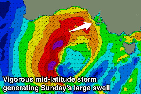 This storm will create a captured fetch scenario with the storm moving at a similar speed to the swell its creating, resulting in larger than normal wave growth.
The XL swell should fill in Sunday, peaking through the middle of the day/afternoon along with strong W/NW tending W/SW winds.
The Mid Coast should see large stormy 4-5ft waves developing with Middleton building to 6-8ft into the afternoon. Protected breaks will be the go for the afternoon, but with a bit less size with the westerly swell direction.
Monday is now unfortunately looking onshore as the front responsible for Sunday's swell lingers just a little too long. Fresh W/SW-SW breezes are due across all locations with easing 3-4ft surf on the Mid and dropping sets from 6ft off Middleton.
Tuesday and Wednesday are the days to surf down South as winds swing offshore from the N/NW on the former and N/NE on the later.
The surf should still be around 3ft off Middleton but easing Tuesday with smaller 2ft waves Wednesday, best at Waits and Parsons.
Longer term some new W/SW swell is expected into Friday and more so next weekend, but more on this Monday. Have a great weekend!
Comments
Commonly known as "victory at sea". How's the little slab off the southern end of Noarlunga Reef!
http://www.bom.gov.au/products/IDS65030.shtml
Looks like a bad buoy reading at cdc .
Looks like it's adrift!