Lots of swell to come, large into Sunday

South Australian Forecast by Craig Brokensha (issued Wednesday 2nd August)
Best Days: Mid Coast tomorrow morning, South Coast Friday onwards (protected spots over the weekend)
Recap
Fun cleaner 1-2ft sets across the Mid Coast yesterday, easing back to the 1.5ft range into the afternoon with variable winds, and then a clean crisp 1ft today.
The South Coast saw good improving waves with plenty of size left across the coast with 3ft sets off Middleton. An afternoon E'ly created bumpy conditions though. Today the swell was good again and fun right across the region for a surf.
This afternoon a good mix of SW and W/SW swell are due to build across both coasts, generated by a strong splitting front Sunday and Monday. We should see the Mid Coast build to 1-2ft later although the tides aren't ideal for a late kick, while the South Coast should see 3ft sets off Middleton.
A mid-latitude low approaching from the west will swing winds more E'ly as well as bring in rain later this evening.
This week and weekend (Aug 3 - 6)
This afternoon's mix of swells should hold into tomorrow morning with similar sized 3ft waves off Middleton and 1-2ft on the Mid Coast as winds swing from the E around to the S'th through the day. This isn't ideal for the South Coast, with cleaner conditions on the Mid.
The swell will ease through the day ahead of new SW groundswell into the afternoon mainly for the South Coast. This swell and a secondary pulse for Friday is being generated by an elongated fetch of gale to severe-gale pre-frontal W/NW winds moving in from the south-east Indian Ocean.
Middleton should persist around 3ft tomorrow afternoon and Friday morning (with strengthening N/NW winds), while the Mid Coast will be around a tiny 1ft early, with a stormy increase in W swell mid-late afternoon as a vigorous mid-latitude front pushes into us.
 This front has already developed west-southwest of WA and will project a fetch of strong to gale-force W/SW winds through our western swell window over the coming days, generating a moderate sized W/SW swell for Saturday.
The Mid Coast should see messy 3ft waves Saturday with a strengthening W/NW wind as another vigorous mid-latitude storm approaches from the west. This may kick wave heights closer to 4ft by dark but we'll review this Friday.
The South Coast should see 3-4ft waves off Middleton all of Saturday and conditions will be favourable with a fresh W/NW tending strong NW breeze.
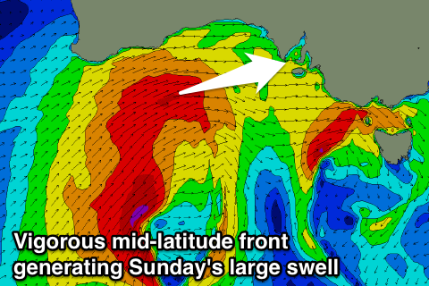
The secondary front is developing in the Heard Island region today and will project a strengthening fetch of W/SW gales up and through our western swell window passing across us later Saturday afternoon and evening.
A large powerful W/SW groundswell will be generated, peaking through Sunday to a stormy 4ft on the Mid Coast with strong W/SW winds and 5-6ft range off Middleton. We may see a morning W/NW'ly around Victor Sunday morning, but Monday looks the pick as the large swell starts to slowly ease under NW winds.
The Mid Coast will also ease from 3ft but remain onshore.
Longer term there's plenty more W/SW swell due through later next week, but more on this Friday.