Fun waves to end the week, large swell building Sunday

South Australian Forecast by Craig Brokensha (issued Wednesday 26th July)
Best Days: South Coast Thursday, both coasts Friday, South Coast Sunday, Mid Coast Monday
Recap
A continuation of tiny bumpy waves across the Mid Coast yesterday, while today a new W/SW swell has lifted sets to 1-2ft with a light to moderate onshore wind.
The South Coast pumped yesterday with a good new S/SW groundswell providing solid 3-4ft waves across the region with offshore winds. Today a reinforcing W/SW swell has kept wave heights up above expectations along with a W'ly wind which has since shifted more W/SW.
This week and weekend (Jul 27 – 30)
We'll see today's W/SW swell drop back rapidly overnight with the front responsible for it moving off to the east today.
Conditions will become great down South with a fresh N'ly tending NW breeze and easing sets from 2ft+ at Middleton, while the Mid Coast is due to be tiny.
A strong mid-latitude front approaching from the west through the day will kick up some new W/SW swell for Friday, with an upgrade in size from Monday with the front being a touch stronger.
Middleton should see 3ft sets through the morning, with 2ft sets on the Mid Coast and variable tending light offshore winds. Another vigorous mid-latitude storm approaching from the west through the day will see winds increasing from the N/NE, but this will keep both coasts nice and relatively clean.
 Friday's swell is expected to ease into Saturday leaving small fading sets down South, while the Mid Coast is likely to see building levels of windswell with a fresh to strong NW tending W/NW breeze.
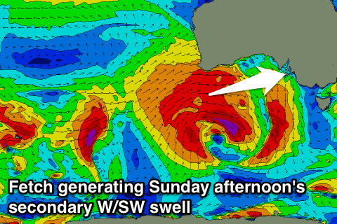
Of greater importance is the W/SW groundswell due off the vigorous mid-latitude forming in our swell window through this week.
This storm is forecast to develop west-southwest of WA over the coming days, with an initial fetch of severe-gale to storm W/NW winds in our swell window early Friday due to produce a long-period W'ly swell for Sunday morning.
We'll then see a better aligned and much broader fetch of severe-gale W/SW winds projected under WA and through the Bight while weakening Friday and Saturday, generating a larger W/SW groundswell for afternoon.
The Mid Coast will be solid all day with messy 3ft waves along with a fresh W/NW tending W'ly breeze.
The South Coast should see 4ft sets off Middleton through the morning, building to a larger 5-6ft through the afternoon with favourable winds for protected locations.
Monday will see the swell still coming in large out of the W/SW, easing through the day but conditions look poor down South and good on the Mid with a S'ly breeze in the wake of an overnight change. More on this Friday.