Long Weekend on target for great waves

South Australian Surf Forecast by Ben Matson (issued Wednesday 30th September)
Best Days: Fri: small new swell on the Mid, but better down south with offshore winds. Sat/Sun/Mon: pulsey long range, long period W/SW swells with fun surf on the Mid and clean but inconsistent surf down south. Tues onwards: extended period of surf but tricky winds at times. Plenty of waves for the Mid though.
Recap: Onshore winds marred a building S’ly swell at Victor on Tuesday, whilst residual swells maintained tiny peelers across the Mid Coast. This morning saw tiny conditions on the Mid with rapidly improving conditions at Victor thanks to a N’ly breeze, and an easing S’ly swell. Sea breezes hit mid-afternoon.
This week (Oct 1- 2)
No major change to the forecast notes issued Monday. The swell period charts are still showing two swell fronts for the coming days; one through this afternoon and another early Friday.
The first swell is still of little interest to me. It source was a pre-frontal NW fetch in the Indian Ocean over the weekend, located a very large distance from the mainland. At the time these notes were prepared (4pm), the Cape Sorell (Tas), Point Nepean (Vic) and Cape du Couedic buoys had yet to detect any sign of new energy, and I’m really not expecting much to eventuate across South Australian beaches on Thursday.
Early light winds are expected to swing W/SW in the morning, so what surf we do see (mainly a small residual mix of S’ly and SW swell from today, around 2ft Middleton) will become bumpy. Small teaser lines are expected to prevail across the Mid Coast.
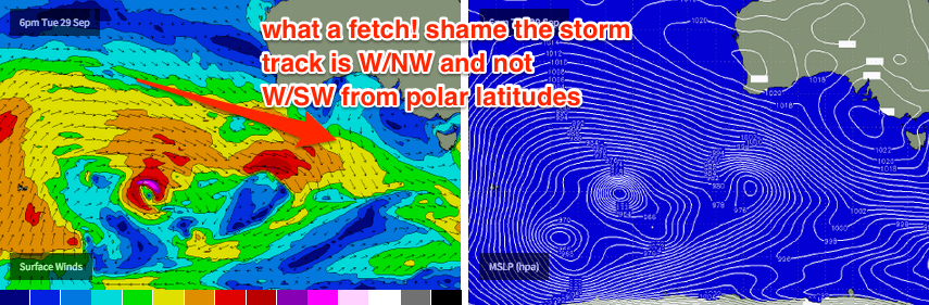
Friday’s new swell is much different, however the bulk of its energy will only favour the South Coast. Although the source is similar to Thursday's swell, there are a couple of characteristics that will probably lead to a fun round of waves for Victor on Friday. First of all, the responsible fetch is located closer to the mainland. Second, an embedded low developing within the W/NW thru’ NW fetch is expected to build on the already-active sea state. And thirdly, as the low reached maturity, the NW storm track is expected to tend straight W’ly, even nudge slightly W/SW for a few hours as it passes through the eastern periphery of our swell window.
This swell is expected to build throughout the day - peaking into the afternoon - and local winds are expected to be N’ly so conditions should be clean on top all day. Middleton should increase to 2-3ft into the afternoon (smaller early morning) and there should be plenty of fun options about the coast.
The Mid Coast is likely to see some small lines of W/SW swell on Friday related the early stages of this weather system, but I’m not expecting much size - perhaps a few stray 1-1.5ft sets on the incoming tide - and it’ll be very inconsistent too. There’s also a mild threat that the northerlies may freshen into the afternoon too, rendering the reefs bumpy. But keep an eye on the South Port cam in case the surf exceeds expectations.
This weekend (Oct 3 - 4)
We’ve got a really good round of long period W'ly tending W/SW swells for the entire Long Weekend.
These new swells will originate from a sustained belt of NW winds on the eastern flank of a large Long Wave Trough in the Southern Indian Ocean. Swell periods will be quite strong thanks to several embedded features within the NW flow that are expected to display very strong winds in excess of 40kts.
Unfortunately, westerly swells often create very large ranges in wave heights across the coast - great for the Mid Coast, but not so great for Victor Harbor - however winds should remain some form of N’ly all weekend (apart from a brief period of light variable winds, possibly onshore, around Sunday afternoon) so Victor should come up trumps anyway.
These new swells will build slowly through Saturday, holding steady into Sunday, and I think the afternoons should both produce good waves in the 2-3ft range across the Mid Coast (smaller in the mornings). Saturday is at risk for N’ly winds to bump up the wave faces but Sunday is the pick of the period with light variable winds all day.
Down south, I’m skeptical that we’ll see anywhere near as much size as what you'd expect from a swell event like this (say, compared to exposed parts of the state), and I think our forecast model for Middleton is slightly overcalling Sunday’s size (3-5ft). To me we’re looking at smaller surf building to 2-3ft+ at Middleton on Saturday with slightly bigger waves through Sunday (3-4ft) - however it’ll be bigger at exposed location, but much smaller closer to Victor.
Let’s take once final pass at the numbers on Friday once the satellite observations are in for the responsible fetches. But for now, it’s looking like a fun weekend of waves.
Next week (Oct 5 onwards)
Sunday’s long period westerly energy will continue through Monday - I think we’ll see a similar size early morning before it tapers off into the afternoon. At this stage N’ly winds are expected to maintain clean conditions down south, but there is a risk of some chop developing across the Mid Coast.
The rest of the forecast period looks quite exciting. Very late Monday, the leading edge of a very long period swell (Tp of around 22-23 seconds) is expected to make landfall. This will have been generated by the main engine room of the Long Wave Trough in the Indian Ocean, and we’re looking at an initial W’ly swell tending W/SW over the coming days.
Tuesday should therefore see a kick in size, and we’re looking at 2-3ft sets across the Mid Coast. However an approaching frontal system is expected to strengthen NW winds about the coast so conditions may become quite bumpy. This swell should increase surf size down south to somewhere between 3ft and maybe 5ft at Middleton by the afternoon, but there’ll be long breaks between the sets.
The trend for Wednesday will be for slightly smaller surf, despite the swell direction swinging W/SW. Unfortunately, the latter stages of the storm cycle is expected to display much weaker winds in our near swell window, so I think the bulk size from this event will be mainly out of the west on Tuesday. That being said there should still be plenty of waves for the South Coast, and the Mid Coast should remain very active with additional energy generated by the front responsible for Tuesday’s late SW change.
Looking beyond this, and a series of strong fronts through the Bight early in the week will then set up another round of active swells from Thursday through into the following weekend, with plenty of waves for the Mid Coast under a dominant westerly swell direction. More on this in Friday’s notes.
Comments
Almost flat down south this morning, but the new swell has kicked in with some clean 2ft sets at Knights and Middleton. Hopefully we'll see a little more size into the afternoon. Conditions look unreal!
Small lines starting to appear along the Mid Coast as expected too, seems to be 1-1.5ft at The Hump.