Fun weekend down south; W'ly swells for the Mid later next week and beyond?

South Australian Surf Forecast by Ben Matson (issued Friday 25th September)
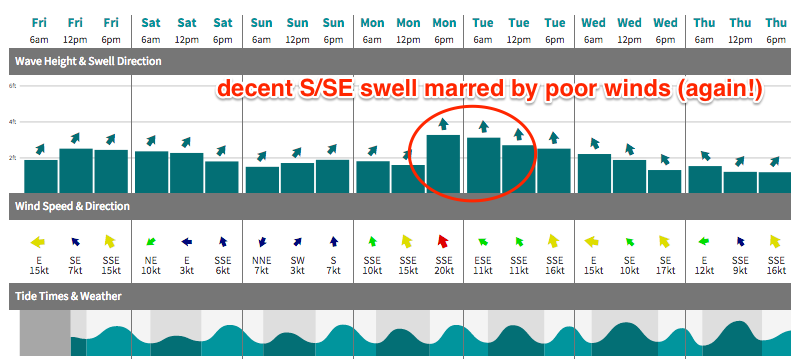
Best Days: South Coast: Sat/Sun: small clean swells with light N/NE winds. Tues: wind affected but strong, unusual S/SE swell. Mid Coast: later next week, weekend and early in the following week: all looking good for some long range W'ly swell.
Recap: Thursday offered tiny clean waves along the Mid Coast, and terrible onshore surf down south. A small improvement occurred at Victor this morning as winds went light N’ly, but they’re now onshore again. The Mid Coast is tiny to finish the week. A small new swell was detected at the CdC buoy today but it’s come in below expectations and therefore we’re seeing just half a foot waves at most breaks.
This weekend (Sep 26 - 27)
With no notable swells expected for the weekend, we can expect the Mid Coast to remain tiny to flat both days. As such, all attention should be focused down south.
And the good news is that winds are looking favourable as a high ridges to the south-east of the state, and a low pressure trough develops in the western Bight and slowly travels eastwards. This should maintain light NE winds on Saturday, tending variable on Sunday.
As for surf, a small pulse of SW swell will maintain inconsistent, 2ft to almost 3ft surf at Middleton on Saturday morning before it eases into the afternoon and further into Sunday. Without any strength in the offshore flow, conditions will still be little lumpy but otherwise the faces should be smooth - if anything the jumbly conditions attributable to the last few days of onshores should help to peak up otherwise straight banks.
Next week (Sep 28 onwards)
Still nothing major on the radar for most of next week at this stage.
Another polar low is expected to intensify immediately S/SW of West Oz (off the ice shelf) today, and it’ll generate a small new SW swell that is due to push through on Monday, maintaining small waves across the South Coast (and not much for the Mid Coast).
Elsewhere, as the trough in the Bight tracks eastward over the weekend, it’s expected to eventually bring a southerly wind change to our region - probably early Monday, and mainly affecting the South Coast (winds should be cross-offshore S/SE on the Mid). However, the timing on the change is not yet clear, and we may see an hour or two at dawn with light winds at Victor - but troughs are notoriously fickle in their timing so we need some elasticity around this (don’t be surprised if it’s a few hours earlier).
The trough’s development is also under consideration as a new swell source. The European model has this trough forming an intense cut-off low immediately west of Tasmania on Monday morning, which - if aimed properly - could generate a strong, and possibly sizeable S’ly, almost S/SE groundswell for the South Coast on Tuesday, easing Wednesday. Unfortunately, it’ll probably be accompanied by gusty S’ly winds so quality (and options) would be limited - see chart below.
It's also worth pointing out that the GFS model (pictured below) doesn't quite form a cut-off low, but still has a stalled trough with some potential for short range energy on Tuesday. But the broadscale synoptic pattern is similar, and that's important.
But none of this is a certainty right now, as it only takes a small realignment of the low away from our swell window to change things considerably. Right now we’re almost four days away from this possible scenario (i.e. Tuesday morning) so I’ll have more information about it on Monday (I’ll also update in these notes over the weekend if the models swing definitively one way or the other).
Otherwise, all eyes are still closely watching a major intensification of the Long Wave Trough over Southern Indian Ocean waters next week, which is still on target for an excellent late season Indo swell.
At this stage - and as per Wednesday’s notes - I’m not expecting this system to line up properly within our SW swell window for quite some time; it’ll probably be the following week (i.e. Oct 5th onwards) where we see any broadscale potential from this patterm.
That being said, we are still looking at some long range westerly groundswell from the leading edge of this system, arriving later next week and into the weekend. It’s still a long time away but we could be looking at some small but fun (and very inconsistent) surf on the Mid Coast for a few days - possibly all the way through the first half of the following week, originating from strong secondary lows trailing behind at the back of the progression. However the South Coast would probably miss out during this period due to the swell direction.
Beyond that, the second half of the following week and the next weekend are more likely to see a general bigger upwards trend in size across the South Coast. More on this in Monday’s notes.
See you Monday - have a great weekend!