Good tomorrow morning, great Friday

South Australian Forecast (issued Wednesday 29th October)
Best Days: Thursday morning down South, Friday down South, Sunday on the Mid, Monday down South
Recap
Yesterday was poor across the Mid Coast with a chopped up 2ft to occasionally 3ft of W/SW swell, while the South Coast was OK in protected locations early with 3ft of swell across the Middleton stretch under fresh to strong W'ly winds. A shift to the S/SW around midday spoilt a late pulse in new strong S/SW groundswell.
The swell filled in solidly overnight and peaked in the cover of darkness, but early this morning the South Coast saw solid 5-6ft waves across most breaks with bigger bombs at offshore reefs and swell magnets. Light morning W/NW winds created clean conditions but the swell has since eased and sea breezes have kicked in. The Mid Coast also saw good conditions this morning with clean 1-2ft sets.
 This week (Oct 30 – 31)
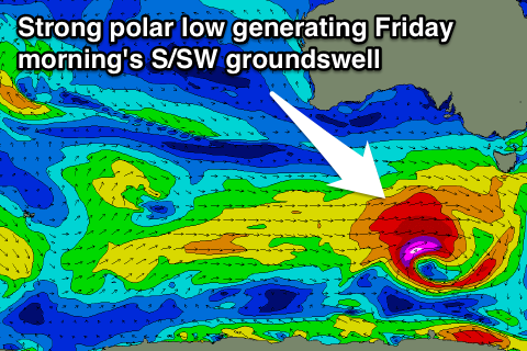
Today's large kick in S/SW groundswell will ease back through tomorrow and bottom out through the middle of the day, but a possible late increase in new S/SW groundswell is on the cards, peaking Friday morning.
This swell is being generated by a secondary polar front firing up south-west of Victoria, close to the polar shelf, with a fetch of severe-gale W/SW winds being generated on the edge of our southern swell window.
Another strong pulse of S/SW swell will result but the size will be a smaller than the increase we saw this morning. Still we should see most spots coming in at 3-5ft Friday morning, with the possibility of the odd bigger bomb to 6ft at Waits and Parsons. The swell should ease through the day and further into Saturday morning.
Conditions tomorrow morning should be good with a variable breeze (tending locally offshore across both coasts) before sea breezes kick in. Friday morning will then be great but a little windy with a fresh to strong N'ly offshore ahead of a shift to the W/NW through the day and late onshore change.
This weekend onwards (Nov 1 onwards)
Late Friday's onshore change will unfortunately linger into the start of the weekend with fresh but easing SW winds due across both coasts into Saturday. A strong new S/SW swell will arrive just behind this change though as broad fetch of SW gales are projected up into Victoria and the South East during Saturday.
This should produce a moderate to large sized S/SW swell for Sunday across the South Coast but winds will remain average and from the S'th tending SE. Middleton should offer messy 4-5ft waves with 6ft sets at Waits, while the Mid Coast will be the pick with clean 1-2ft waves.
Monday morning will be the pick across the South Coast next week as the swell eases under N/NE tending variable winds.
Longer term there's nothing too major on the cards besides a longer-range W/SW groundswell for Thursday but with SE winds, the Mid Coast will offer the best waves. More on this Friday though.