Great Thursday, large swell with dicey winds Sunday

South Australian Forecast (issued Wednesday 8th October)
Best Days: Thursday down South, early Friday down South, Sunday morning down South
Recap
Yesterday was average with an improving 1-2ft of swell across the Mid as onshore winds backed off through the afternoon, while the South Coast was fun early with a W'ly wind before fresh onshores kicked in.
Today was much better as a stronger SW groundswell filled in down South under offshore winds, while the Mid was tiny, clean and ideal for beginners.
This week (Oct 9 - 10)
Another reinforcing SW swell from mid-latitude frontal activity under the country is due into tomorrow morning, keeping 3ft sets hitting Middleton with 4ft+ waves out at Waits and Parsons ahead of a slight drop through the afternoon and more noticeable easing trend through Friday and further into Saturday morning.
Thursday will be the pick with offshore N'ly tending variable winds, creating a full day of good waves. Come Friday a funky trough moving in from the west will create average onshore S/SE winds once it hits, but at dawn and early morning winds should be variable across both coasts.
This weekend onwards (Oct 11 onwards)
 Saturday will be a day to miss as winds linger onshore from the S/SE across the South Coast as the swell bottoms out.
Our large SW groundswell for Sunday and Monday is still on track but winds are a little tricky to forecast at the moment with the models diverging regarding a surface trough/low moving in from the west.
The system does look to stall a little to our west now which would result in NW'ly winds through Sunday morning but a strong SW change is expected to move through around lunch with strong but easing S/SW winds into Monday.
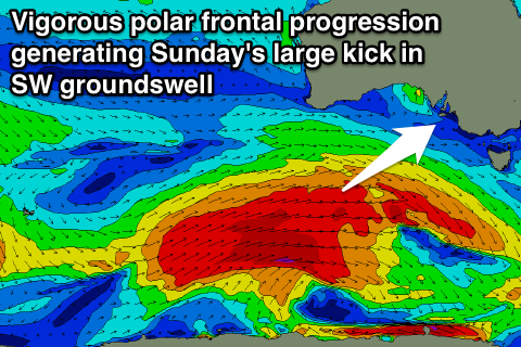
Coming back to the swell though, a strong node (peak) of the Long Wave Trough moving through later this week will steer a couple of vigorous polar fronts through our south-western swell window through the coming days and into the start of the weekend.
A large SW groundswell should result, building through Sunday, peaking through the afternoon before easing into Monday. The Mid should reach 2ft+ while the South Coast is expected to build to 4-6ft at Middleton, with larger bombs at Waits.
With all the divergence around the winds though, we'll have to review this outlook on Friday but in the meantime keep an eye on the 6 hourly model updates on whether we'll see a longer period of more favourable winds on Sunday morning.