Lots of swell, dicey winds

South Australian Forecast (issued Monday 29th September)
Best Days: Tuesday down South, Wednesday across both coasts for keen surfers, Thursday on the Mid, Friday morning down South, Saturday down South
Recap
Saturday was excellent down South with warm offshore winds and a solid easing swell opening up plenty of options right across the coast. Sunday was poor with strong to gale-force offshore winds down South and tiny choppy waves on the Mid.
Today fresh levels of W/SW groundswell are building across both coasts, coming in at a choppy 2ft across the Mid this morning and starting off small and clean down South, but a further kick has been seen with good waves around Middleton out of the W/NW wind.
This week (Sep 30 – Oct 3)
Today's building W/SW groundswell will be replaced by a larger increase in SW swell through tomorrow, generated by a vigorous and broad front that's currently passing south of WA. A fetch of W/SW gales are generating a large open ocean sea state, with large levels of SW swell expected to spread up into us tomorrow afternoon, peaking overnight and easing Wednesday.
The Mid Coast should offer 2-3ft waves through tomorrow before easing from a similar size Wednesday, while Middleton is expected to build to 4-5ft later tomorrow afternoon with 6ft+ sets at Waits.
Wednesday morning should see solid 4-6ft waves at Middleton and 6-8ft sets at Waits, easing through the day and further through Thursday.
Now, winds tomorrow will be great for the South Coast during the morning and offshore from the W/NW with strength ahead of a strong W/SW change through the day. This change unfortunately looks to linger into Wednesday with moderate S/SW winds across the South Coast but they're expected to ease rapidly and swing more SW, opening options for keen surfers into the afternoon.
The Mid Coast will be workable as well with the weaker S/SW breeze, with fun waves across most reefs and beaches.
 Thursday looks good across the Mid Coast as the swell eases from 1-2ft with light offshore SE winds during the morning that should hold from the S'th into the afternoon. The South Coast however may be average again with the S/SW tending S/SE breeze creating bumpy conditions across most locations.
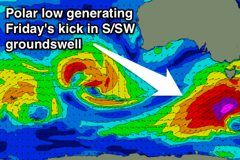
Into Friday a new acute S/SW groundswell is due to impact the South Coast, created by a vigorous polar low forming late in our swell window to the south-west of Tassie. Although forming late, a fetch of severe-gale to storm-force SW winds will be generated just within our swell window, producing a good S/SW groundswell for Friday.
The models look to be combining this swell with the easing swell from Thursday, over-forecasting the size expected down South, with most locations due to build to 3-5ft during the day. Winds should be good during the morning and offshore from the N/NE but we'll review this Wednesday.
This weekend onwards (Oct 4 onwards)
Saturday is looking great again for a surf down South (for about the third weekend in a row) as Friday's S/SW groundswell eases steadily from 3-4ft at Middleton with 5ft sets at Waits under fresh N/NW winds.
Sunday will become small and an early onshore change will create average conditions across both coasts.
Into next week a couple of swells are on the cards but nothing off any major significance and winds will become poor after favourable offshores Monday. We'll have another look at this on Wednesday though.
Comments
Hey Craig. Thx for the info mate. I have a Q for ya, when you talk about the models, what models do you use to look at the swell heading our way?
Cheers Mate.
I use our own WAMs (top right) to look at the swell forecast by the American GFS model.
This is what all the other virtual buoy forecast sites use as well, but I also take into account what the European model (ECMWF) forecasts wind wise for the same storms as well as a couple of the other models (not anywhere near as much).
In a perfect world it'd be great to get ECMWF forecasts into the Wave Watch model, but the data is way too expensive to buy, hence the reason why everyone else uses the free American GFS wind inputs.
Thanks for the info Craig.