Pumping Saturday, plenty of size but with west winds next week

South Australian Forecast (issued Friday 26th September)
Best Days: Saturday down South, early Sunday for keen surfers (but tricky with wind), Monday afternoon down South, Tuesday and early Wednesday down South and on the Mid
Recap
Yesterday was a day to miss with onshore winds and a small swell down South while the Mid was a bumpy 1-1.5ft.
Today, a much better and stronger long-range SW groundswell has filled in with 2ft sets on the Mid under light to moderate N/NW winds, while the South Coast was clean and in the 3-4ft range at Middleton with 5ft+ surf out at Waits under W/NW winds.
We should see winds tend more variable across the Mid this afternoon creating glassy conditions into the evening, and the South Coast was expected to see the same outlook but winds have already gone onshore from the SW around Goolwa, but are holding up around Victor and Middleton.
This weekend (Sep 27 - 28)
Tomorrow will be excellent down South with an easing SW groundswell from today under fresh and warm N/NW winds. The Middleton stretch should ease from 3ft to occasionally 4ft with 5ft sets at Waits for experienced surfers, while the Mid will be bumpy and easing from 1-1.5ft under the fresh to strong N'ly breeze.
Sunday will be tricky and probably not worth the drive from Adelaide with a small leftover swell and strong N'ly wind ahead of a W'ly change through the day kicking up a choppy and weak 1-2ft of windswell across the Mid.
Next week onwards (Sep 29 onwards)
As indicated the last few updates, the outlook into next week is much more active as a strong node (peak) of the Long Wave Trough moves through the Bight Sunday and then across us through Monday evening.
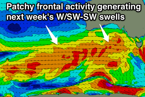 This will steer a flurry of frontal activity initially through our western swell window and then our south-west window, but the only issue is that each front will be quite patchy in nature with winds in the gale-force range (down from the forecast severe-gale range earlier in the week).
Still we should see an initial moderate sized increase in W/SW swell Monday to 2-3ft on the Mid Coast during the afternoon, while the South Coast should build from 2-3ft at Middleton and 3-4ft at Waits to 3ft+ and 4-5ft respectively during the afternoon.
A secondary better pulse of SW groundswell is due into Tuesday afternoon and Wednesday from a better aligned fetch of W/SW gales at a more southern latitude, in our south-western swell window.
This should see Middleton building to 3-5ft during Tuesday with 4-6ft sets at Waits while the Mid should persist in the 2ft+ range Tuesday before easing from 2ft Wednesday.
Winds will be best for the South Coast with fresh and gusty NW tending W/NW breeze Monday and then W/NW tending W/SW winds on Tuesday. Wednesday looks a little dicey with a W/SW breeze expected for the most part besides an early W'ly around Victor Harbor favouring protected locations.
The Mid Coast will be average through the whole swell event until possibly Wednesday morning when a variable breeze may be seen, but Thursday will see definite offshore winds from the east as the swells fades from 1-1.5ft. The South Coast will also continue to ease into the end of the week as winds swing to the E/NE Thursday and better from the N'th Friday.
We'll look at this in more detail on Monday though. Have a great weekend!