Large and onshore Thursday, clean and easing Friday

South Australian Forecast (issued Wednesday 10th September)
Best Days: Friday both coasts, Saturday down South, Sunday arvo on the Mid, Monday morning both coasts, Tuesday down South
Recap
The Mid Coast started slow and onshore yesterday morning before building to 2ft through the afternoon. The South Coast was also small and clean, but a new swell showed into the afternoon with fun waves across Middleton and other semi-protected breaks.
Today stronger levels of W/SW swell have started to fill in with inconsistent and lumpy 2ft waves on the Mid, while the South Coast is showing better 2-3ft sets at Middleton and 3-4ft waves out at Waits under strengthening W/NW winds. The swell should kick further this afternoon across the Mid Coast, reaching 3ft as conditions deteriorate with the strengthening W/NW wind.
This week and weekend (Sep 11 - 14)
Tomorrow's large mix of W/SW and SW groundswell are still in track but conditions will be poor with a fresh to strong SW change now due to move through just on dawn. This will create choppy and stormy conditions across both coasts with a swell to 3ft+ on the Mid and building waves to 6ft at Middleton and 8ft at Waits into the afternoon.
Friday is the day to surf as a ridge of high pressure quickly moves in from the west, resulting in winds tending variable and locally offshore from the N'th down South and E across the Mid Coast.
The Mid should drop from 2ft to possibly 3ft early, while the South Coast is expected to still be solid and in the 5-6ft range at Middleton, with the odd bigger bomb at Waits and Parsons.
Saturday looks great down South as winds remain offshore for most of the day from the N/NW ahead of a late and weak onshore change. The swell will still likely be too solid for Waits and Parsons, with Middleton the pick with easing 3-5ft sets. The Mid should still be clean but more so tiny and in the 1-1.5ft range.
Sunday looks dicey across the South Coast as onshore winds linger in the wake of an overnight change and then freshen from the S/SE into the afternoon.
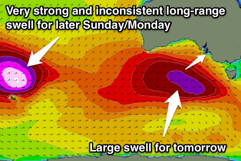 The Mid Coast however should see the arrival of a very long-range and inconsistent but powerful W/SW groundswell during the afternoon. This swell is currently being generated in the Southern Indian Ocean by one of the strongest polar storms we've seen this year.
A fetch of severe-gale to storm-force W/SW winds are generating an open ocean sea state of around 60ft, with the swell periods associated with this swell expected to reach out to 24-25s.
This is a very long way away from us, and there'll be considerable swell decay, but the swell still arrive through Sunday and offer very infrequent 2ft sets on the Mid late in the day.
Next Monday onwards (Sep 15 onwards)
Sunday afternoon's pulse of W/SW groundswell across the Mid should hold into Monday morning to a very inconsistent 2ft on the sets, while the swell should peak across the South Coast through the morning to 3-4ft+ at Middleton and 5ft at Waits. E/NE tending S/SE winds will favour the Mid over the South Coast, while as the swell eases Tuesday, offshore N'ly winds will create great conditions down South.