Fun weekend at exposed breaks, large swells for the second half of next week

South Australian Forecast (issued Friday 5th September)
Best Days: Saturday at exposed spots, Sunday, early Monday, later Tuesday down South, Wednesday down South, Thursday morning down South
Recap
The Mid offered tiny 1ft lines yesterday which pulsed a little into the afternoon with the incoming tide as winds remained offshore.
The South Coast was small and clean during the morning, but a new swell filled in through the afternoon as winds tended a little more NE. This favoured slightly protected locations across the coast.
This morning the swell was still hanging in across the South Coast to an inconsistent 2-3ft at Middleton with bigger sets at Waits but conditions weren't as favourable with light morning E'ly winds and peaky options across the coast. The Mid Coast continued in the tiny 1ft range, ideal for beginners.
This weekend (Sep 6 – 7)
Tomorrow will start out real slow with a small leftover swell from this morning under NE tending E/NE winds. A new swell is due into the afternoon, but protected locations out of the easterly wind will be the only real decent option.
A better S/SW groundswell is due to fill in Sunday as winds swing straighter offshore from the N/NE. This should provide good 2-3ft waves at Middleton with 3-4ft sets at Waits worth getting stuck into. There's no rush as the swell is expected to arrive at sometime during the morning.
Next week onwards (Sep 8 onwards)
 Monday morning will still be great across exposed locations but you'll have to get in early as the swell will drop quickly under strong offshore N/NE tending N/NW winds.
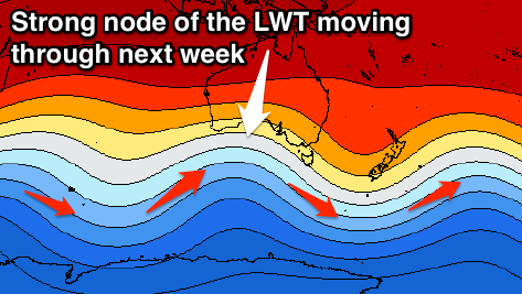
As touched on the last few updates, the outlook is much better from mid next week all due to a strong node of the Long Wave Trough pushing west from the Southern Indian Ocean, across the south of the country through the Bight Tuesday and then across us Wednesday.
This will bring with it a series of vigorous polar fronts that will be initially quite north in latitude and in our western swell window ahead of a better aligned and strongest system projecting towards us from Monday through Wednesday.
So initial levels of acute W'ly swell are due Tuesday, building to 2ft on the Mid Coast and only slightly down South to 2ft at Middleton and 3ft at Waits into the afternoon.
Into Wednesday though some better W/SW groundswell mixed in with windswell across the Mid is expected, with the largest pulse due Thursday afternoon.
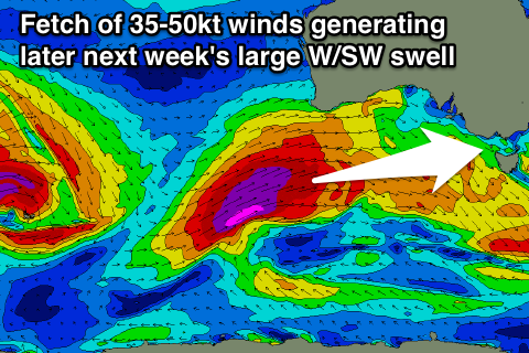 This will be generated by the strongest of all the fronts, firing up just east of Heard Island and projecting a fetch of severe-gale to sub-storm-force W/SW winds right up towards and through the Bight.
A large and powerful W/SW groundswell will result, filling in strongly Thursday and peaking through the afternoon on the Mid to 3-4ft while the South Coast should kick to 6ft at Middleton late in the day, with 8ft bombs at Waits and Parsons. A drop in size is then due across the Mid Friday from 3ft, while the swell should still be large and around the same size across the South Coast ahead of a drop into the afternoon.
Winds will be favourable for the South Coast Wednesday and Thursday morning, but a W/SW tending S/SW change will create poor conditions from around late morning Thursday into Friday. The Mid Coast will be poor for the most part before cleaning up later Friday as winds tend more S'ly, but more on this Monday. Have a great weekend!