Exposed spots down South the pick

South Australian Forecast (issued Wednesday 3rd September)
Best Days: Thursday morning, Friday morning, Sunday, Monday
Recap
The Mid Coast saw a weak but improving 1-2ft of short-range SW swell yesterday, while the South Coast was average with fresh but easing onshore winds.
Today is much better down South with light offshore winds and a fun easing S/SW swell from 3ft across most breaks. The swell should ease into this afternoon as winds remain favourable.
This week and weekend (Sep 4 – 7)
Tomorrow should be fun again down South, but the morning will be small ahead of an afternoon increase in long-range SW groundswell.
Middleton should increase from 1-2ft to 2ft+ into the afternoon with 3ft+ sets developing at Waits. Morning N/NE winds will swing SE into the afternoon, so the morning up until early afternoon will be the pick. Friday morning should be fun as the SW groundswell eases slowly and winds swing back to the E/NE, creating peaky but clean conditions. Get out through the morning though, as SE winds will create poor conditions from late morning.
The start of the weekend will be slow with a small swell and NE tending E'ly winds.
Sunday will be the pick as a new long-range S/SW groundswell fills in, building to 2-3ft at Middleton and 3-4ft at Waits through the day. Conditions should be good most of the day with a N/NE tending NE breeze.
Next week onwards (Sep 8 onwards)
Monday morning will be the best of early next week with an easing swell from Sunday under fresh to strong N/NE winds. The afternoon will become small with tiny waves Tuesday with fresh to strong NW winds.
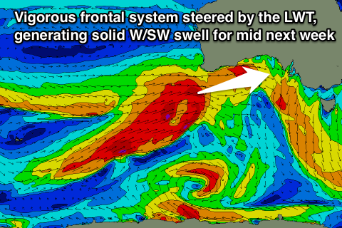 From Wednesday though the outlook is much better as a strong node of the Long Wave Trough push east from the Indian Ocean towards us into the middle of the week.
A series of vigorous polar fronts will be directed up and into us, generating pulses of W/SW groundswell that will more than likely reach the large range into the second half of the week.
Check back here on Friday though for an update on the timing and sizes of the W/SW groundswells due through the middle to end of next week.