Large swells and winds from the western quadrant

South Australian Forecast (issued Monday 7th July)
Best Days: Tuesday morning down South, Wednesday afternoon and Thursday morning for keen surfers on the Mid Coast, Thursday in protected locations and Friday down South
Recap
The Mid offered semi-stormy 3ft waves through Saturday that eased as winds backed off into the afternoon. Sunday morning was average with a small leftover swell and persisting onshores.
The South Coast performed best with a moderate sized swell and W'ly winds, limting the best waves to protected locations. Sunday was much better with a dropping 2-3ft of swell across Middleton with bigger sets at Waits under light offshore winds before a fresh SW change moved through.
Today the surf is great down South with a fun sized swell and straight offshore, while the Mid Coast is tiny and bumpy.
This week (Jul 7 – Jul 11)
Tomorrow will remain super fun during the morning down South, but you'll have to surf before lunch as strong N/NW winds into the afternoon may create tricky conditions. A new long-range W/SW groundswell should provide good 2ft to nearly 3ft waves along the Middleton stretch with bigger sets near 4ft at Waits with a fresh to strong N'ly through the morning.
Wednesday is probably a day to miss down South with W'ly winds and a mix of in between swells, but the Mid Coast should kick up to the 3ft range through the afternoon as a strong new W/SW groundswell fills in along with localised windswell.
The strong W/SW groundswell is currently being generated by a vigorous polar front pushing up and into WA under the influence of the Long Wave Trough. The front will push through the Bight tomorrow and across us during Wednesday.
A peak in groundswell is due overnight Wednesday but the Mid should still see 3ft waves into Thursday morning before easing through the day.
The South Coast however will see a mix of large SW swell in the water as well Thursday as a fetch of SW gales are projected up into Victor on the backside of the front Wednesday evening and Thursday morning.
This should see Middleton coming in at 5-6ft through the middle of the day along with larger bombs at Waits and Parsons. Winds for the most part look average with a strong but easing W/SW'ly, but this will more than likely turn W'ly around Victor at stages through the day.
Friday looks the pick though with a moderate sized and easing SW swell and offshore NW winds that are expected to tend more W/NW through the day.
This weekend onwards (Jul 12 onwards)
The LWT will move across us through the end of the week while weakening, and with this we'll see the polar frontal activity focussed up into us and Victoria.
 One such system will start its life down near Heard Island and push gradually up towards us while weakening through the coming week.
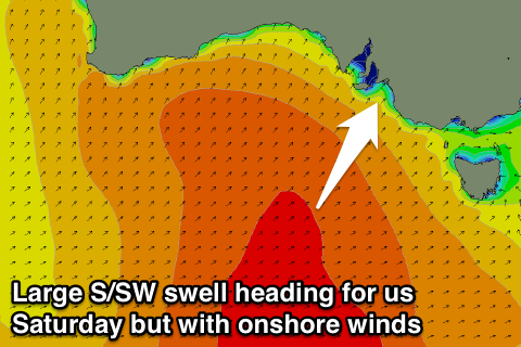
A large S/SW groundswell should result, filling in and peaking Saturday afternoon but unfortunately winds look to go onshore Saturday morning and remain so into Sunday as the swell backs off. The S/SW direction will not favour the Mid and only a tiny 1ft+ wave is expected through the weekend, albeit with clean conditions Sunday.
Longer term there's plenty more swell on the way but check back here on Wednesday for more on this.